IMAGES TAKEN NEAR TO
Swan Lane, CRICKHOWELL, NP8 1PE
Introduction
This page details the photographs taken nearby to Swan Lane, NP8 1PE by members of the Geograph project.
The Geograph project started in 2005 with the aim of publishing, organising and preserving representative images for every square kilometre of Great Britain, Ireland and the Isle of Man.

There are currently over 7.5m images from over14,400 individuals and you can help contribute to the project by visiting https://www.geograph.org.uk
Image Map (Loading...)


Getting Data...Please wait
Leaflet Map data © OpenStreetMap
Images are licensed for reuse under creativecommons.org/licenses/by-sa/2.0
Notes
- Clicking on the map will re-center to the selected point.
- The higher the marker number, the further away the image location is from the centre of the postcode.
Image Listing (107 Images Found)
Images are licensed for reuse under creativecommons.org/licenses/by-sa/2.0
Image
Details
Distance
1
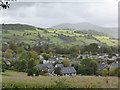
Llangattock, Powys
Autumn is coming to the sheltered valley of the Usk.
Image: © Jeremy Bolwell
Taken: 20 Oct 2013
0.01 miles
2
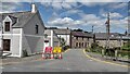
Road Ahead Closed
From Hillside Road Owens Road ahead closed
Image: © Shaun Ferguson
Taken: 5 Jun 2021
0.02 miles
3

Narrow street ahead, Llangattock
Viewed from opposite The Old Six Bells. http://www.geograph.org.uk/photo/3035721
The block of steps was (and still could be) used for mounting a horse.
Image: © Jaggery
Taken: 17 Jun 2012
0.02 miles
4

Cottages on the bank of Nant Onnau, Llangattock
Behind the cottages is a stream, Nant Onnau, http://www.geograph.org.uk/photo/3035764 a tributary of the River Usk.
Image: © Jaggery
Taken: 17 Jun 2012
0.02 miles
5

Nant Onnau downstream, Llangattock
Viewed from the edge of Hillside Road. The stream Nant Onnau flows away from the camera towards its confluence http://www.geograph.org.uk/photo/3037346 with the River Usk at Crickhowell Bridge, about 700 metres away.
Image: © Jaggery
Taken: 17 Jun 2012
0.02 miles
6

Nant Onnau upstream, Llangattock
Viewed from near the corner of Hillside Road. The stream Nant Onnau flows towards the camera.
Its confluence http://www.geograph.org.uk/photo/3037346 with the River Usk is at Crickhowell Bridge, about 700 metres away.
Image: © Jaggery
Taken: 17 Jun 2012
0.02 miles
7

Stone bridge and houses, Llangattock
Viewed from near the Hillside Road junction.
The stone bridge is over a stream, Nant Onnau. http://www.geograph.org.uk/photo/3035758 http://www.geograph.org.uk/photo/3035764
Image: © Jaggery
Taken: 17 Jun 2012
0.02 miles
8
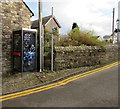
BT phonebox in Llangattock
In Swan Lane, at the edge of the bridge over a stream, Nant Onnau.
Double yellow lines indicate no parking at any time.
Image: © Jaggery
Taken: 22 Nov 2015
0.03 miles
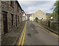
9
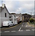
Junction of Hillside Road and Swan Lane, Llangattock
Double yellow lines on both sides of narrow Swan Lane indicate no parking at any time.
Behind the van are the stone walls of a bridge across a stream, Nant Onnau.
Image: © Jaggery
Taken: 22 Nov 2015
0.03 miles
10
Ancient and modern, Swan Lane, Llangattock
On both sides of the lane, modern double yellow lines contrast with ancient cobbled pavements.
Image: © Jaggery
Taken: 22 Nov 2015
0.03 miles