1
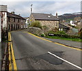
Park View, Llangattock
Stone house viewed across Hillside Road.
Image: © Jaggery
Taken: 22 Nov 2015
0.00 miles
2
Nant Onneu below Owen's Close, Llangattock
Looking downstream between village houses and gardens.
Image: © M J Roscoe
Taken: 10 Jul 2020
0.01 miles
3
Signpost in a hedge, Llangattock
On the corner of Swan Lane and Hillside Road, half a mile from Dardy,
three-quarters of a mile from Crickhowell and seven and a quarter miles from Beaufort.
Image: © Jaggery
Taken: 22 Nov 2015
0.01 miles
4
No parking anywhere here, Swan Lane, Llangattock
In addition to the double yellow lines on both sides of Swan Lane
indicating no parking at any time, a notice at the edge of a track shows NO PARKING.
Image: © Jaggery
Taken: 22 Nov 2015
0.02 miles
5
Old Corn Mill, Llangattock
The name on the single-storey building is THE OLD CORN MILL.
An edge of a derelict former pub is on the right. http://www.geograph.org.uk/photo/4748049
Image: © Jaggery
Taken: 22 Nov 2015
0.02 miles
6
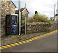
BT phonebox in Llangattock
In Swan Lane, at the edge of the bridge over a stream, Nant Onnau.
Double yellow lines indicate no parking at any time.
Image: © Jaggery
Taken: 22 Nov 2015
0.02 miles
7
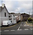
Junction of Hillside Road and Swan Lane, Llangattock
Double yellow lines on both sides of narrow Swan Lane indicate no parking at any time.
Behind the van are the stone walls of a bridge across a stream, Nant Onnau.
Image: © Jaggery
Taken: 22 Nov 2015
0.02 miles
8
Hillside Road past a derelict pub in Llangattock
In November 2015 the Horse Shoe Inn name and pub sign remain on the derelict pub.
Metal sheets cover the door and ground floor windows. http://www.geograph.org.uk/photo/4748049
Image: © Jaggery
Taken: 22 Nov 2015
0.02 miles
9
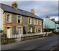
Row of three houses, Hillside Road, Llangattock
Behind the houses is a derelict former pub. http://www.geograph.org.uk/photo/4748049
Image: © Jaggery
Taken: 22 Nov 2015
0.02 miles
10
Horse Shoe Inn, Llangattock
Viewed from Park Drive. The pub is located on Hillside Road, a short distance from the centre of the village. This view http://www.geograph.org.uk/photo/1413913 taken 3 years earlier shows the pub painted white.
Update November 2015. The pub has closed down. http://www.geograph.org.uk/photo/4748049
Image: © Jaggery
Taken: 17 Jun 2012
0.03 miles


