IMAGES TAKEN NEAR TO
Church Close, CRICKHOWELL, NP8 1NY
Introduction
This page details the photographs taken nearby to Church Close, NP8 1NY by members of the Geograph project.
The Geograph project started in 2005 with the aim of publishing, organising and preserving representative images for every square kilometre of Great Britain, Ireland and the Isle of Man.

There are currently over 7.5m images from over14,400 individuals and you can help contribute to the project by visiting https://www.geograph.org.uk
Image Map
Images are licensed for reuse under creativecommons.org/licenses/by-sa/2.0
Notes
- Clicking on the map will re-center to the selected point.
- The higher the marker number, the further away the image location is from the centre of the postcode.
Image Listing (46 Images Found)
Images are licensed for reuse under creativecommons.org/licenses/by-sa/2.0
Image
Details
Distance
1
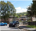
School entrance, Llangynidr
The entrance to Llangynidr Primary School is from Church Close.
Image: © Jaggery
Taken: 17 Jun 2012
0.03 miles
2
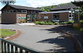
North side of Llangynidr Primary School
Viewed from Church Close Llangynidr.
Image: © Jaggery
Taken: 17 Jun 2012
0.04 miles
3
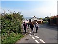
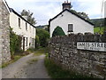
Llangynidr
Cerddwyr yn gadael pentre Llangynidr.
Walkers leaving Llangyndir Village (trans. St Cynidr Church).
Image: © Alan Richards
Taken: 4 Oct 2015
0.05 miles
4
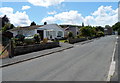
Church Close, Llangynidr
Cul-de-sac on the SW side of Castle Road.
Image: © Jaggery
Taken: 17 Jun 2012
0.07 miles
5
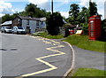
Red phonebox at a bend in Duffryn Road, Llangynidr
The phonebox and yellow grit box are near the entrance path http://www.geograph.org.uk/photo/4109644
to the Church in Wales Parish Church of St Cynidr & St Mary.
Image: © Jaggery
Taken: 17 Jun 2012
0.08 miles
6
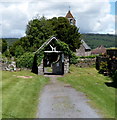
Lychgate, Llangynidr
On the entrance path from Duffryn Road to the Parish Church of St Cynidr & St Mary. http://www.geograph.org.uk/photo/4109601
The lychgate formerly sheltered a coffin until the clergyman's arrival for the burial, or pre-burial service.
Image: © Jaggery
Taken: 17 Jun 2012
0.08 miles
9
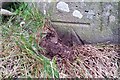
Ordnance Survey Cut Mark
This OS cut mark can be found on the south angle of St Cynidr & St Mary's Church. It marks a point 130.022m above mean sea level.
Image: © Adrian Dust
Taken: 19 Jan 2019
0.10 miles
10
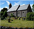
South side of the Church in Wales church in Llangynidr
Viewed from Duffryn Road. The Parish Church of St Cynidr & St Mary is in the
Church in Wales Parish of Llangattock & Llangynidr, in the Diocese of Swansea and Brecon.
Image: © Jaggery
Taken: 17 Jun 2012
0.10 miles