IMAGES TAKEN NEAR TO
Groesfford, CRICKHOWELL, NP8 1NH
Introduction
This page details the photographs taken nearby to Groesfford, NP8 1NH by members of the Geograph project.
The Geograph project started in 2005 with the aim of publishing, organising and preserving representative images for every square kilometre of Great Britain, Ireland and the Isle of Man.

There are currently over 7.5m images from over14,400 individuals and you can help contribute to the project by visiting https://www.geograph.org.uk
Image Map
Images are licensed for reuse under creativecommons.org/licenses/by-sa/2.0
Notes
- Clicking on the map will re-center to the selected point.
- The higher the marker number, the further away the image location is from the centre of the postcode.
Image Listing (47 Images Found)
Images are licensed for reuse under creativecommons.org/licenses/by-sa/2.0
Image
Details
Distance
1
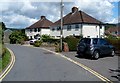
Duffryn Road houses near the Red Lion pub in Llangynidr
The pub http://www.geograph.org.uk/photo/4109739 is just out of shot around the corner.
Image: © Jaggery
Taken: 17 Jun 2012
0.04 miles
2
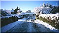
Llangynidr
Approaching the village from the north, having driven as close as the roads would allow. Very attractive Usk Valley village.
Image: © Richard Webb
Taken: Unknown
0.05 miles
3
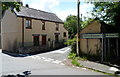
Distances from crossroads in Llangynidr
Located near the Red Lion. http://www.geograph.org.uk/photo/4109739
Left for Dyffyrn Crawnon (4 miles), right for Brecon (10 miles).
Image: © Jaggery
Taken: 17 Jun 2012
0.06 miles
4
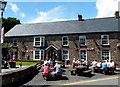
Outside the Red Lion in Llangynidr
Most of the picnic tables outside the Duffryn Road pub are occupied on a warm sunny day in June 2012.
Image: © Jaggery
Taken: 17 Jun 2012
0.06 miles
5
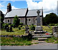
Llangynidr War Memorial
Located in the SE corner of the village churchyard adjacent to Duffryn Road.
The Parish Church of St Cynidr & St Mary is in the background.
Image: © Jaggery
Taken: 17 Jun 2012
0.06 miles
6
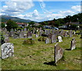
Llangynidr churchyard
The SW corner of the churchyard of the Parish Church of St Cynidr & St Mary. http://www.geograph.org.uk/photo/4109601
Image: © Jaggery
Taken: 17 Jun 2012
0.07 miles
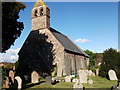
7
St Cynidr & St Mary's church, Llangynidr
Image: © David Purchase
Taken: 14 Oct 2017
0.07 miles
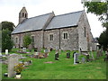
8
Church of St Cynidr and St Mary, Llangynidr
According to the Clwyd-Powys Archaeological Trust website, https://cpat.org.uk/Archive/churches/brecon/16877.htm the site of the church dates from the early medieval era, the buildings being restored in the 19th century, and rebuilt again in 1928 following a fire.
Image: © John Brightley
Taken: 24 Oct 2010
0.07 miles
9
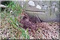
Ordnance Survey Cut Mark
This OS cut mark can be found on the south angle of St Cynidr & St Mary's Church. It marks a point 130.022m above mean sea level.
Image: © Adrian Dust
Taken: 19 Jan 2019
0.08 miles
10
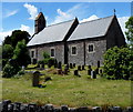
South side of the Church in Wales church in Llangynidr
Viewed from Duffryn Road. The Parish Church of St Cynidr & St Mary is in the
Church in Wales Parish of Llangattock & Llangynidr, in the Diocese of Swansea and Brecon.
Image: © Jaggery
Taken: 17 Jun 2012
0.08 miles