IMAGES TAKEN NEAR TO
Castle Road, CRICKHOWELL, NP8 1NG
Introduction
This page details the photographs taken nearby to Castle Road, NP8 1NG by members of the Geograph project.
The Geograph project started in 2005 with the aim of publishing, organising and preserving representative images for every square kilometre of Great Britain, Ireland and the Isle of Man.

There are currently over 7.5m images from over14,400 individuals and you can help contribute to the project by visiting https://www.geograph.org.uk
Image Map
Images are licensed for reuse under creativecommons.org/licenses/by-sa/2.0
Notes
- Clicking on the map will re-center to the selected point.
- The higher the marker number, the further away the image location is from the centre of the postcode.
Image Listing (25 Images Found)
Images are licensed for reuse under creativecommons.org/licenses/by-sa/2.0
Image
Details
Distance
1
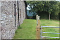
Public footpath next to Castle Farm
The low wall on the grass public footpath to Cwm Crawnon Road is a stile!
Image: © M J Roscoe
Taken: 12 Aug 2017
0.00 miles
2
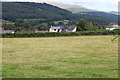
Field, Castle Farm, Llangynidr
Field next to Castle Farm; most of the houses in the background are on Cwm Crawnon Road. The woodland beyond is on Myarth with part of the Black Mountains in the distance.
Image: © M J Roscoe
Taken: 12 Aug 2017
0.08 miles
3
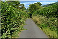
Castle Road, Llangynidr
Made even narrower by the encroaching summer vegetation.
Image: © David Martin
Taken: 16 Jul 2017
0.14 miles
4
Erw Bant, Llangynidr
Cul-de-sac on the west side of the B4560 Forge Road.
Image: © Jaggery
Taken: 17 Jun 2012
0.17 miles
5
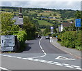
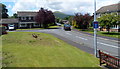
Junction in Llangynidr
Left along the B4558 for Talybont-on-Usk and Brecon. Ahead for Bwlch along the B4560 Forge Road where restrictions apply - light vehicles only, and the blue sign on the right states Check your width. This is all very vague - weight and width limits are not given.
Image: © Jaggery
Taken: 17 Jun 2012
0.18 miles
6
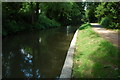
Brecon and Monmouthshire Canal
The Brecon and Monmouthshire Canal at Llangynidr. The canal briefly enters this grid square.
Image: © Philip Halling
Taken: 20 Jun 2009
0.19 miles
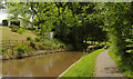
7
Monmouthshire and Brecon Canal at Llangynidr
Looking left from Image], as the canal passes the rear of houses on Pen-Yr-Ale Lane. The towpath is followed by Llangynidr footpath 47/1, the Usk Valley Walk and the Beacons Way.
Image: © Derek Harper
Taken: 24 Jun 2021
0.19 miles
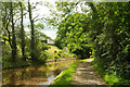
8
Monmouthshire and Brecon Canal at Llangynidr
Taken a few metres further along the towpath from Image The towpath carries Llangynidr footpath 47/1, the Usk Valley Walk and the Beacons Way.
Image: © Derek Harper
Taken: 24 Jun 2021
0.20 miles
9
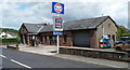
Llangynidr Service Station
Gulf filling station alongside the B4560 Forge Road, Llangynidr.
Image: © Jaggery
Taken: 17 Jun 2012
0.20 miles
10
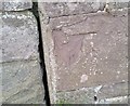
Ordnance Survey Cut Mark
This damaged OS cut mark can be found on Bromelys, Forge Road. It marked a point 117.830m above mean sea level.
Image: © Adrian Dust
Taken: 28 Jan 2019
0.21 miles