IMAGES TAKEN NEAR TO
Chapel Field, CRICKHOWELL, NP8 1LJ
Introduction
This page details the photographs taken nearby to Chapel Field, NP8 1LJ by members of the Geograph project.
The Geograph project started in 2005 with the aim of publishing, organising and preserving representative images for every square kilometre of Great Britain, Ireland and the Isle of Man.

There are currently over 7.5m images from over14,400 individuals and you can help contribute to the project by visiting https://www.geograph.org.uk
Image Map
Images are licensed for reuse under creativecommons.org/licenses/by-sa/2.0
Notes
- Clicking on the map will re-center to the selected point.
- The higher the marker number, the further away the image location is from the centre of the postcode.
Image Listing (67 Images Found)
Images are licensed for reuse under creativecommons.org/licenses/by-sa/2.0
Image
Details
Distance
1
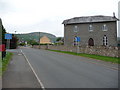
A large chapel in Llangattock
A large chapel sits beside the road here, now surrounded by houses and bungalows, and ahead stands the impressive hillside of Craig y Cilau.
Image: © Jeremy Bolwell
Taken: 5 Jun 2011
0.03 miles
2
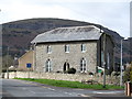
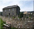
Bethesda Chapel, Llangattock
Situated in a prominent position near the top end of the village, the chapel dates from 1835 and was built on a site donated by Sir Joseph Bailey of Glanusk Park. Grade 2 listed.
Image: © Gordon Hatton
Taken: 12 Apr 2015
0.03 miles
3
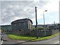
Bethesda Chapel, Llangattock
A grade 2 listed building.
Image: © Christine Johnstone
Taken: 14 Sep 2013
0.03 miles
4
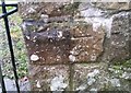
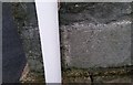
Ordnance Survey Cut Mark
This OS cut mark can be found on the north face of the wall of the Bethesda Chapel. It marks a point 101.157m above mean sea level.
Image: © Adrian Dust
Taken: 19 Jan 2019
0.04 miles
5
Ordnance Survey Cut Mark
This OS cut mark can be found on the SE angle of the Bethesda Chapel. It marks a point 102.395m above mean sea level.
Image: © Adrian Dust
Taken: 19 Jan 2019
0.04 miles
6
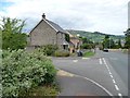
Hillside Road, Llangattock
Looking north-eastwards, to distant Crickhowell.
Image: © Christine Johnstone
Taken: 14 Sep 2013
0.04 miles
8

Hillside Road, Llangattock
Approaching the chapel
Image: © Geoff Pick
Taken: 12 Aug 2010
0.04 miles
9
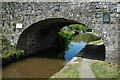
Bridge 115, Monmouthshire and Brecon Canal
Bridge 115 on the Monmouthshire and Brecon Canal in Llangattock.
Image: © Philip Halling
Taken: 23 May 2009
0.06 miles
10
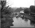
Upper Yard Bridge No 115, Monmouthshire and Brecon Canal
Image: © Dr Neil Clifton
Taken: 20 Sep 1987
0.07 miles