IMAGES TAKEN NEAR TO
Hillside, Llangattock, CRICKHOWELL, NP8 1LG
Introduction
This page details the photographs taken nearby to NP8 1LG by members of the Geograph project.
The Geograph project started in 2005 with the aim of publishing, organising and preserving representative images for every square kilometre of Great Britain, Ireland and the Isle of Man.

There are currently over 7.5m images from over14,400 individuals and you can help contribute to the project by visiting https://www.geograph.org.uk
Image Map
Images are licensed for reuse under creativecommons.org/licenses/by-sa/2.0
Notes
- Clicking on the map will re-center to the selected point.
- The higher the marker number, the further away the image location is from the centre of the postcode.
Image Listing (5 Images Found)
Images are licensed for reuse under creativecommons.org/licenses/by-sa/2.0
Image
Details
Distance
1
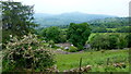
Steep hillside above the Usk
Cottages and smallholdings on this hillside to the south of Llangattock.
Plus a fine view across the Usk valley to Y Fal.
Image: © Jonathan Billinger
Taken: 10 Jun 2016
0.17 miles
2
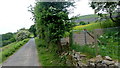
Lane at Pant-y-rhiw
Lane contours the steep hillside to the south of Llangattock.
Image: © Jonathan Billinger
Taken: 10 Jun 2016
0.18 miles
3
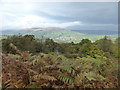
View towards Crickhowell from above Llangattock
Warm autumn sunshine chases over the Crickhowell area.
Image: © Jeremy Bolwell
Taken: 19 Oct 2013
0.18 miles
4
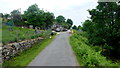
Hillside community
Cottages and smallholdings on this hillside to the south of Llangattock.
Image: © Jonathan Billinger
Taken: 10 Jun 2016
0.20 miles
5
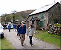
White Walls
Cerddwyr yn mynd heibio i anhedd-dy o'r enw White Walls.
Walkers passing a property known as White Walls.
Image: © Alan Richards
Taken: 22 Apr 2012
0.21 miles