IMAGES TAKEN NEAR TO
Llangattock, CRICKHOWELL, NP8 1LE
Introduction
This page details the photographs taken nearby to NP8 1LE by members of the Geograph project.
The Geograph project started in 2005 with the aim of publishing, organising and preserving representative images for every square kilometre of Great Britain, Ireland and the Isle of Man.

There are currently over 7.5m images from over14,400 individuals and you can help contribute to the project by visiting https://www.geograph.org.uk
Image Map
Images are licensed for reuse under creativecommons.org/licenses/by-sa/2.0
Notes
- Clicking on the map will re-center to the selected point.
- The higher the marker number, the further away the image location is from the centre of the postcode.
Image Listing (2 Images Found)
Images are licensed for reuse under creativecommons.org/licenses/by-sa/2.0
Image
Details
Distance
1
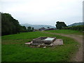
Drinking troughs near Cilau Farm, Llangattock
These two brick and concrete water containers are stock drinking troughs I think. They are situated in fields beside the footpath and farm track. They bear the legend 'J. Harris, R. Miles 1983'. A fine piece of handiwork they are too. It's nice to see that Messrs. Harris and Miles took a pride in their work. 1983, seems like yesterday...
Image: © Jeremy Bolwell
Taken: 5 Jun 2011
0.08 miles
2
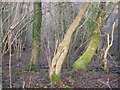
Coed y Cilau
Semi-natural woodland in the valley of a mountain stream.
Image: © Graham Cole
Taken: 28 Jan 2008
0.25 miles