IMAGES TAKEN NEAR TO
Glanonney Gardens, CRICKHOWELL, NP8 1HQ
Introduction
This page details the photographs taken nearby to Glanonney Gardens, NP8 1HQ by members of the Geograph project.
The Geograph project started in 2005 with the aim of publishing, organising and preserving representative images for every square kilometre of Great Britain, Ireland and the Isle of Man.

There are currently over 7.5m images from over14,400 individuals and you can help contribute to the project by visiting https://www.geograph.org.uk
Image Map
Images are licensed for reuse under creativecommons.org/licenses/by-sa/2.0
Notes
- Clicking on the map will re-center to the selected point.
- The higher the marker number, the further away the image location is from the centre of the postcode.
Image Listing (134 Images Found)
Images are licensed for reuse under creativecommons.org/licenses/by-sa/2.0
Image
Details
Distance
1
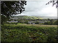
View to Llangattock from the canal towpath
The mountain is the Sugar Loaf down at Abergavenny.
Image: © Jeremy Bolwell
Taken: 20 Oct 2013
0.08 miles
2
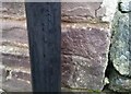
Ordnance Survey Cut Mark
This OS cut mark can be found on the Ty Saer Coed. It marks a point 86.450m above mean sea level.
Image: © Adrian Dust
Taken: 19 Jan 2019
0.09 miles
3

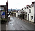
Narrow street ahead, Llangattock
Viewed from opposite The Old Six Bells. http://www.geograph.org.uk/photo/3035721
The block of steps was (and still could be) used for mounting a horse.
Image: © Jaggery
Taken: 17 Jun 2012
0.10 miles
4

Cottages on the bank of Nant Onnau, Llangattock
Behind the cottages is a stream, Nant Onnau, http://www.geograph.org.uk/photo/3035764 a tributary of the River Usk.
Image: © Jaggery
Taken: 17 Jun 2012
0.10 miles
5

Nant Onnau downstream, Llangattock
Viewed from the edge of Hillside Road. The stream Nant Onnau flows away from the camera towards its confluence http://www.geograph.org.uk/photo/3037346 with the River Usk at Crickhowell Bridge, about 700 metres away.
Image: © Jaggery
Taken: 17 Jun 2012
0.10 miles
6

Nant Onnau upstream, Llangattock
Viewed from near the corner of Hillside Road. The stream Nant Onnau flows towards the camera.
Its confluence http://www.geograph.org.uk/photo/3037346 with the River Usk is at Crickhowell Bridge, about 700 metres away.
Image: © Jaggery
Taken: 17 Jun 2012
0.10 miles
7

Stone bridge and houses, Llangattock
Viewed from near the Hillside Road junction.
The stone bridge is over a stream, Nant Onnau. http://www.geograph.org.uk/photo/3035758 http://www.geograph.org.uk/photo/3035764
Image: © Jaggery
Taken: 17 Jun 2012
0.10 miles
8
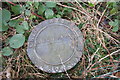
Boundary Post
This cast iron marker apparently delineates a boundary of the old Great Western Railway Co's (as at 1917) - perhaps with the tracks of the old Monmouthshire Railway & Canal Co. or the old local tramway lines?
Image: © Dave Pinniger
Taken: 29 Dec 2007
0.11 miles
9
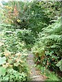
Steps on a public footpath, west of Llangattock
Dropping down steeply from the canal towpath to Nant Onney [Onney valley].
Image: © Christine Johnstone
Taken: 14 Sep 2013
0.11 miles
10
Bilingual priority over oncoming vehicles sign, Llangattock
The Welsh and English sign faces Hillside Road.
Image: © Jaggery
Taken: 22 Nov 2015
0.11 miles