IMAGES TAKEN NEAR TO
The Legar, CRICKHOWELL, NP8 1HH
Introduction
This page details the photographs taken nearby to The Legar, NP8 1HH by members of the Geograph project.
The Geograph project started in 2005 with the aim of publishing, organising and preserving representative images for every square kilometre of Great Britain, Ireland and the Isle of Man.

There are currently over 7.5m images from over14,400 individuals and you can help contribute to the project by visiting https://www.geograph.org.uk
Image Map
Images are licensed for reuse under creativecommons.org/licenses/by-sa/2.0
Notes
- Clicking on the map will re-center to the selected point.
- The higher the marker number, the further away the image location is from the centre of the postcode.
Image Listing (264 Images Found)
Images are licensed for reuse under creativecommons.org/licenses/by-sa/2.0
Image
Details
Distance
1
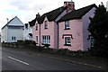
Pink cottage in Legar
Pink-painted Rose Cottage is alongside the A4077 in Legar, a hamlet near Crickhowell.
Some references name the hamlet "The Legar" whereas a boundary sign nearby shows only LEGAR. http://www.geograph.org.uk/photo/4747565
Image: © Jaggery
Taken: 22 Nov 2015
0.00 miles
2
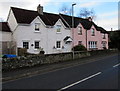
Kate's Cottage, Legar
Viewed across the A4077 in Legar, a hamlet near Crickhowell.
Kate's Cottage is on the left. Pink-painted Rose Cottage http://www.geograph.org.uk/photo/4757559 is on the right.
Image: © Jaggery
Taken: 22 Nov 2015
0.00 miles
3
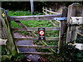
Dim Baeddu/No Fouling notice, Legar
The bilingual (Welsh/English) notice is on a wooden gate at the entrance to a footpath on the south side of the A4077 in Legar (or The Legar), a hamlet near Crickhowell. The Brecon Beacons National Park insignia is at the bottom of the notice.
Image: © Jaggery
Taken: 22 Nov 2015
0.01 miles
4

From metal railings to stone wall, Legar
A change in the perimeter of a riverside field on the north side of the A4077 in Legar near Crickhowell.
Image: © Jaggery
Taken: 22 Nov 2015
0.02 miles
5
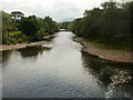
River Usk downstream from Crickhowell Bridge
The Usk heads towards Gilwern.
Image: © Jaggery
Taken: 30 Jun 2010
0.03 miles
6
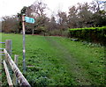
Public footpath, Legar
A Public Footpath sign points towards a well-trodden track through a field
on the south side of the A4077 in Legar, a hamlet near Crickhowell.
Image: © Jaggery
Taken: 22 Nov 2015
0.03 miles
7
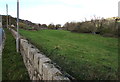
Riverside field, Legar
Between the stone wall at the edge of the A4077 in the hamlet of Legar (near Crickhowell) and the River Usk.
Image: © Jaggery
Taken: 22 Nov 2015
0.03 miles
8
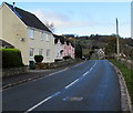
A4077 through Legar
This part of the A4077 is between houses in the hamlet of Legar
near Crickhowell and the perimeter wall of a field on a bank of the River Usk.
Image: © Jaggery
Taken: 22 Nov 2015
0.03 miles
9
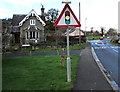
Warning sign - traffic lights ahead, Legar
The sign is alongside the A4077 in Legar, a hamlet near Crickhowell.
Traffic lights 160 metres ahead maintain an alternating flow of traffic across
Crickhowell Bridge (over the River Usk) where the roadway is only one lane wide.
Park Farm Lodge http://www.geograph.org.uk/photo/4747714 is on the left.
Image: © Jaggery
Taken: 22 Nov 2015
0.04 miles
10

Old railway wagon body in a Legar field near Crickhowell
On the right, the dark green structure is one of many thousands
of former railway wagon bodies in use as sheds etc throughout the UK.
Image: © Jaggery
Taken: 22 Nov 2015
0.04 miles