IMAGES TAKEN NEAR TO
Llangenny, CRICKHOWELL, NP8 1EY
Introduction
This page details the photographs taken nearby to NP8 1EY by members of the Geograph project.
The Geograph project started in 2005 with the aim of publishing, organising and preserving representative images for every square kilometre of Great Britain, Ireland and the Isle of Man.

There are currently over 7.5m images from over14,400 individuals and you can help contribute to the project by visiting https://www.geograph.org.uk
Image Map
Images are licensed for reuse under creativecommons.org/licenses/by-sa/2.0
Notes
- Clicking on the map will re-center to the selected point.
- The higher the marker number, the further away the image location is from the centre of the postcode.
Image Listing (14 Images Found)
Images are licensed for reuse under creativecommons.org/licenses/by-sa/2.0
Image
Details
Distance
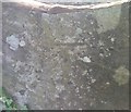
1
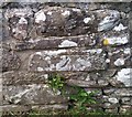
Ordnance Survey Cut Mark
This OS cut mark can be found on a wall south side of the road. It marks a point 80.596m above mean sea level.
Image: © Adrian Dust
Taken: 6 Jul 2020
0.02 miles
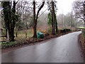
2
Dead-end side road south of Llangenny, Powys
On the west side of the road from Glangrwyney to Llangenny, the road leads to The Old Mill and Millbrook House.
Image: © Jaggery
Taken: 20 Jan 2019
0.05 miles
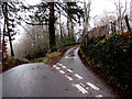
3
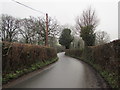
Hedge-lined road towards Llangenny, Powys
Minor road north from Glangrwyney.
Image: © Jaggery
Taken: 20 Jan 2019
0.06 miles
4
Kill your speed, not a child sign on the southern approach to Llangenny, Powys
https://www.geograph.org.uk/photo/6030996 to a closer view of the non-standard sign on a wooden post.
Image: © Jaggery
Taken: 20 Jan 2019
0.08 miles
5
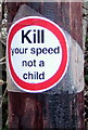
Kill your speed, not a child sign detail near Llangenny, Powys
The non-standard sign on the wooden post here https://www.geograph.org.uk/photo/6030995 is one
of several similar signs on display in this area in January 2019.
Image: © Jaggery
Taken: 20 Jan 2019
0.08 miles
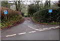
6
Minor road junction south of Llangenny, Powys
Take the left fork for Llangenny. A sign on the wooden pole on the right shows Mountain Bike Route. https://www.geograph.org.uk/photo/6031000
Image: © Jaggery
Taken: 20 Jan 2019
0.16 miles
7
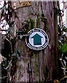
Mountain Bike Route direction sign near Llangenny, Powys
On the wooden post on the right here. https://www.geograph.org.uk/photo/6030998 The text is also in Welsh.
Image: © Jaggery
Taken: 20 Jan 2019
0.16 miles
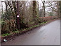
8
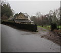
Entrance to Tyn-y-pwll south of Llangenny, Powys
From the minor road from Glangrwyney to Llangenny.
Image: © Jaggery
Taken: 20 Jan 2019
0.18 miles
9
Ordnance Survey Cut Mark
This OS cut mark can be found on a stile east side of the road. It marks a point 90.584m above mean sea level.
Image: © Adrian Dust
Taken: 6 Jul 2020
0.20 miles
10
Green grit bin south of Llangenny, Powys
Alongside the minor road from Glangrwyney to Llangenny.
Image: © Jaggery
Taken: 20 Jan 2019
0.20 miles