IMAGES TAKEN NEAR TO
Glangrwyney, CRICKHOWELL, NP8 1EL
Introduction
This page details the photographs taken nearby to NP8 1EL by members of the Geograph project.
The Geograph project started in 2005 with the aim of publishing, organising and preserving representative images for every square kilometre of Great Britain, Ireland and the Isle of Man.

There are currently over 7.5m images from over14,400 individuals and you can help contribute to the project by visiting https://www.geograph.org.uk
Image Map
Images are licensed for reuse under creativecommons.org/licenses/by-sa/2.0
Notes
- Clicking on the map will re-center to the selected point.
- The higher the marker number, the further away the image location is from the centre of the postcode.
Image Listing (89 Images Found)
Images are licensed for reuse under creativecommons.org/licenses/by-sa/2.0
Image
Details
Distance
1
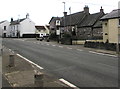
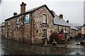
East along the A40, Glangrwyney, Powys
The A40 is the main road through Glangrwyney. Ahead for Abergavenny.
The Bell pub is on the right. https://www.geograph.org.uk/photo/6013578
Image: © Jaggery
Taken: 1 Jan 2019
0.01 miles
2
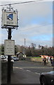
The Bell name sign, Glangrwyney, Powys
Alongside the A40 at the northwest edge of this https://www.geograph.org.uk/photo/6013578 pub.
Image: © Jaggery
Taken: 1 Jan 2019
0.02 miles
3
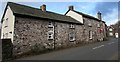
East side of the Bell pub, Glangrwyney, Powys
The Glangrwyney Road side of this https://www.geograph.org.uk/photo/6013549 pub alongside the A40.
Image: © Jaggery
Taken: 1 Jan 2019
0.02 miles
4
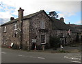
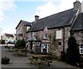
The Bell, Glangrwyney, Powys
Pub with separate bar and dining areas located alongside the A40 on the corner of Glangrwyney Road.
Image: © Jaggery
Taken: 1 Jan 2019
0.02 miles
5
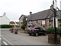
Picnic tables outside the Bell, Glangrwyney, Powys
On the A40 side of the pub on the corner of Glangrwyney Road viewed on January 1st 2019.
Image: © Jaggery
Taken: 1 Jan 2019
0.02 miles
6
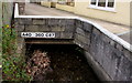
A40 360 C87 identifier on a small bridge over a brook, Glangrwyney, Powys
On the south side of the A40, the main road through the village.
Image: © Jaggery
Taken: 1 Jan 2019
0.02 miles
7
The Bell Country Pub, Glangrwyney
Beside the A40. A country pub with accommodation.
Image: © Eirian Evans
Taken: 26 Aug 2021
0.02 miles
8
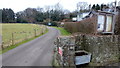
Footpath north from Glangrwyney
A water trough here would seem to be a rare throwback to the horse-drawn age.
Image: © Jonathan Billinger
Taken: 5 Feb 2015
0.02 miles
10
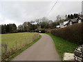
Public footpath on the north side of the A40, Glangrwyney, Powys
Pointing ahead, a public footpath sign is near the camera.
Image: © Jaggery
Taken: 1 Jan 2019
0.02 miles