IMAGES TAKEN NEAR TO
Abergavenny Road, CRICKHOWELL, NP8 1ED
Introduction
This page details the photographs taken nearby to Abergavenny Road, NP8 1ED by members of the Geograph project.
The Geograph project started in 2005 with the aim of publishing, organising and preserving representative images for every square kilometre of Great Britain, Ireland and the Isle of Man.

There are currently over 7.5m images from over14,400 individuals and you can help contribute to the project by visiting https://www.geograph.org.uk
Image Map
Images are licensed for reuse under creativecommons.org/licenses/by-sa/2.0
Notes
- Clicking on the map will re-center to the selected point.
- The higher the marker number, the further away the image location is from the centre of the postcode.
Image Listing (4 Images Found)
Images are licensed for reuse under creativecommons.org/licenses/by-sa/2.0
Image
Details
Distance
1
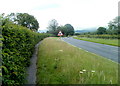
A40 footpath SE of Crickhowell
Early summer (mid-June) vegetation is beginning to encroach on a footpath alongside the A40, about a kilometre SE of Crickhowell.
Image: © Jaggery
Taken: 19 Jun 2011
0.14 miles
2
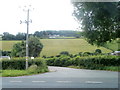
Access lane to Rheld Farm, Powys
Viewed across the A40, about a kilometre SE of Crickhowell. The farm produces Rheld Dairy Ice Cream. Varieties include The Crickhowell Crunch and Penderyn Whisky Ice Cream.
Image: © Jaggery
Taken: 19 Jun 2011
0.14 miles
3
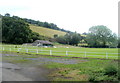
Elvicta football ground near Crickhowell
Located on the north side of the A40, about 400 metres SE of Crickhowell, close to Elvicta Business Park. There is a small covered stand facing the halfway line.
The ground is the home venue for Crickhowell Football Club.
Image: © Jaggery
Taken: 19 Jun 2011
0.14 miles
4
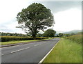
Towering oak, A40 near Crickhowell
An oak dominates this section of the A40, viewed from near the turning into the Rheld Farm access lane. http://www.geograph.org.uk/photo/2469509
Image: © Jaggery
Taken: 19 Jun 2011
0.18 miles