IMAGES TAKEN NEAR TO
Darren View, CRICKHOWELL, NP8 1DS
Introduction
This page details the photographs taken nearby to Darren View, NP8 1DS by members of the Geograph project.
The Geograph project started in 2005 with the aim of publishing, organising and preserving representative images for every square kilometre of Great Britain, Ireland and the Isle of Man.

There are currently over 7.5m images from over14,400 individuals and you can help contribute to the project by visiting https://www.geograph.org.uk
Image Map
Images are licensed for reuse under creativecommons.org/licenses/by-sa/2.0
Notes
- Clicking on the map will re-center to the selected point.
- The higher the marker number, the further away the image location is from the centre of the postcode.
Image Listing (61 Images Found)
Images are licensed for reuse under creativecommons.org/licenses/by-sa/2.0
Image
Details
Distance
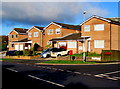
1
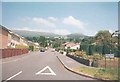
Darren View
This 1960's estate road points almost directly to the Crug Hywel, the outcrop after which the town of Crickhowell is named.
Image: © Jonathan Billinger
Taken: 2 Aug 1998
0.02 miles
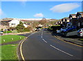
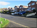
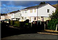
2
Darren View, Crickhowell
Viewed from Oakfield Drive looking NNE.
Image: © Jaggery
Taken: 19 Dec 2014
0.02 miles
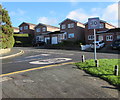
3
West side of Darren View, Crickhowell
From the corner of Oakfield Drive.
Image: © Jaggery
Taken: 22 Nov 2015
0.02 miles
4
Cwmbeth Close, Crickhowell
Viewed from Oakfield Drive which bends to the left at the Cwmbeth Close junction.
Out of shot ahead, Cwmbeth Close ends on the east bank of Cwmbeth Brook.
Image: © Jaggery
Taken: 22 Nov 2015
0.04 miles
5
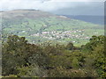
Crickhowell viewed from the Llangattock escarpment
There can't be many better sited small towns in all of Wales than south-facing, compact and characterful Crickhowell nestled in the Usk Valley below Crug Hywel / Table Mountain and lofty Pen Cerrig-calch.
Image: © Jeremy Bolwell
Taken: 19 Oct 2013
0.05 miles
6
Cwmbeth Close houses, Crickhowell
From the corner of Oakfield Drive.
Image: © Jaggery
Taken: 22 Nov 2015
0.05 miles
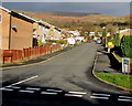
7
From 20 to 30, Oakfield Drive, Crickhowell
The 20mph speed limit in the vicinity of Crickhowell Community Primary School increases to 30mph at the Cwmbeth Close junction.
Image: © Jaggery
Taken: 22 Nov 2015
0.09 miles
8
Ysgol/School warning sign, Oakfield Drive, Crickhowell
The bilingual (Welsh/English) sign is on the approach to Crickhowell Community Primary School.
Image: © Jaggery
Taken: 22 Nov 2015
0.09 miles
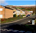
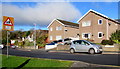
9
Oakfield Drive houses, Crickhowell
On the west side of the Darren View junction.
Image: © Jaggery
Taken: 22 Nov 2015
0.09 miles
10
Ffynnonau houses, Crickhowell
Part of a roughly rectangular area of houses on the west side of Llanbedr Road.
Image: © Jaggery
Taken: 19 Dec 2014
0.10 miles