1
Oakfield Drive electricity substation, Crickhowell
The identifier on the Western Power Distribution electricity substation
on the south side of Oakfield Drive is OAKFIELD DRIVE CRICKHOWELL S/S No. 615326.
Image: © Jaggery
Taken: 19 Dec 2014
0.02 miles
2
Oakfield Drive bungalows in Crickhowell
Strictly, a bungalow is a lightly-built house, with a veranda and one storey.
In current UK usage it is a convenient word for any one-storey dwelling.
Image: © Jaggery
Taken: 19 Dec 2014
0.03 miles
3
Oakfield Drive houses, Crickhowell
On the west side of the Darren View junction.
Image: © Jaggery
Taken: 22 Nov 2015
0.04 miles
4
From 20 to 30, Oakfield Drive, Crickhowell
The 20mph speed limit in the vicinity of Crickhowell Community Primary School increases to 30mph at the Cwmbeth Close junction.
Image: © Jaggery
Taken: 22 Nov 2015
0.07 miles
5
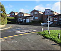
Ysgol/School warning sign, Oakfield Drive, Crickhowell
The bilingual (Welsh/English) sign is on the approach to Crickhowell Community Primary School.
Image: © Jaggery
Taken: 22 Nov 2015
0.07 miles
6
Ffynnonau houses, Crickhowell
Part of a roughly rectangular area of houses on the west side of Llanbedr Road.
Image: © Jaggery
Taken: 19 Dec 2014
0.07 miles
7
Cwmbeth Close houses, Crickhowell
From the corner of Oakfield Drive.
Image: © Jaggery
Taken: 22 Nov 2015
0.08 miles
8
Path towards Bryn Nant, Crickhowell
Looking west towards Bryn Nant houses from an open space north of Rectory Road.
Image: © Jaggery
Taken: 22 Nov 2015
0.08 miles
9
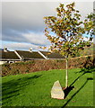
Queen's Diamond Jubilee Tree, Crickhowell
Located in the open space between Rectory Road and Bryn Nant, viewed in November 2015. The plaque on the stone records that the tree was planted by Crickhowell Town Council in 2012. 2012 was the 60th anniversary of the accession of Queen Elizabeth II on February 6th 1952.
Image: © Jaggery
Taken: 22 Nov 2015
0.09 miles
10
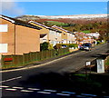
West side of Darren View, Crickhowell
From the corner of Oakfield Drive.
Image: © Jaggery
Taken: 22 Nov 2015
0.09 miles


