IMAGES TAKEN NEAR TO
Brynant, CRICKHOWELL, NP8 1DP
Introduction
This page details the photographs taken nearby to Brynant, NP8 1DP by members of the Geograph project.
The Geograph project started in 2005 with the aim of publishing, organising and preserving representative images for every square kilometre of Great Britain, Ireland and the Isle of Man.

There are currently over 7.5m images from over14,400 individuals and you can help contribute to the project by visiting https://www.geograph.org.uk
Image Map
Images are licensed for reuse under creativecommons.org/licenses/by-sa/2.0
Notes
- Clicking on the map will re-center to the selected point.
- The higher the marker number, the further away the image location is from the centre of the postcode.
Image Listing (182 Images Found)
Images are licensed for reuse under creativecommons.org/licenses/by-sa/2.0
Image
Details
Distance
1
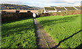
Path towards Bryn Nant, Crickhowell
Looking west towards Bryn Nant houses from an open space north of Rectory Road.
Image: © Jaggery
Taken: 22 Nov 2015
0.03 miles
2
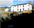
Grade II listed St David's Rectory, Crickhowell
Viewed from Rectory Road. The Historic Wales website states that the Reverend George Bevan founded a Dame School here on the site of a Tithe Barn sometime between 1812 and 1829. After 1837 it was converted into a vicarage which, following the resignation of the last sinecure rector in 1851, became the Rectory. It was extended in the 1860s and sold in 1976. Grade II listed in 1986.
Image: © Jaggery
Taken: 22 Nov 2015
0.04 miles
3
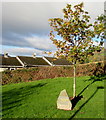
Queen's Diamond Jubilee Tree, Crickhowell
Located in the open space between Rectory Road and Bryn Nant, viewed in November 2015. The plaque on the stone records that the tree was planted by Crickhowell Town Council in 2012. 2012 was the 60th anniversary of the accession of Queen Elizabeth II on February 6th 1952.
Image: © Jaggery
Taken: 22 Nov 2015
0.05 miles
4
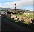
Old-style lamppost, Rectory Road, Crickhowell
The metal arm high up on the left side of the lamppost (probably for a gaslighter to rest his ladder) suggests that the electric street light may have been converted from a gas light.
Image: © Jaggery
Taken: 22 Nov 2015
0.05 miles
5
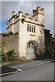
Porth Mawr gatehouse
Porth Mawr is a late 15th century gatehouse on Brecon Road in Crickhowell. It was the gatehouse of the Herbert house of Cwrt-y-carw which is no longer standing.
Image: © Philip Halling
Taken: 5 May 2021
0.07 miles
6
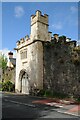
Porth Mawr gatehouse
Porth Mawr is a late 15th century gatehouse on Brecon Road in Crickhowell. It was the gatehouse of the Herbert house of Cwrt-y-carw which is no longer standing.
Image: © Philip Halling
Taken: 5 May 2021
0.07 miles
7
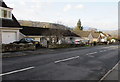
Oakfield Drive bungalows in Crickhowell
Strictly, a bungalow is a lightly-built house, with a veranda and one storey.
In current UK usage it is a convenient word for any one-storey dwelling.
Image: © Jaggery
Taken: 19 Dec 2014
0.08 miles
8
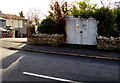
Oakfield Drive electricity substation, Crickhowell
The identifier on the Western Power Distribution electricity substation
on the south side of Oakfield Drive is OAKFIELD DRIVE CRICKHOWELL S/S No. 615326.
Image: © Jaggery
Taken: 19 Dec 2014
0.09 miles
9
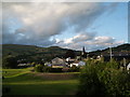
Crickhowell - view from the bridge on a June evening
Image: © Keith Salvesen
Taken: 19 Jun 2008
0.09 miles
10
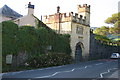
The old gateway of Porth Mawr
The A40 at Crickhowell passes the old gateway of Porth Mawr
Image: © Shaun Ferguson
Taken: 26 Aug 2007
0.10 miles