IMAGES TAKEN NEAR TO
Llanbedr Road, CRICKHOWELL, NP8 1BY
Introduction
This page details the photographs taken nearby to Llanbedr Road, NP8 1BY by members of the Geograph project.
The Geograph project started in 2005 with the aim of publishing, organising and preserving representative images for every square kilometre of Great Britain, Ireland and the Isle of Man.

There are currently over 7.5m images from over14,400 individuals and you can help contribute to the project by visiting https://www.geograph.org.uk
Image Map
Images are licensed for reuse under creativecommons.org/licenses/by-sa/2.0
Notes
- Clicking on the map will re-center to the selected point.
- The higher the marker number, the further away the image location is from the centre of the postcode.
Image Listing (75 Images Found)
Images are licensed for reuse under creativecommons.org/licenses/by-sa/2.0
Image
Details
Distance
1
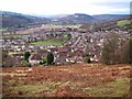
View over Crickhowell from Coed Cefn
The 'ridge wood' is now owned and managed by the Woodland Trust and provides an opportunity for local people (and visitors from further afield!) to enjoy the beech and conifer covered top of this Old Red Sandstone hill. The occasional outward views such as this one westward up the Usk valley over a part of Crickhowell are very much to be enjoyed.
Image: © Alan Bowring
Taken: 21 Dec 2008
0.01 miles
2
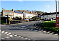
Houses at the NE end of Danygrug, Crickhowell
Viewed across Llanbedr Road from the corner of Oakfield Drive.
Image: © Jaggery
Taken: 19 Dec 2014
0.03 miles
3
Houses at the northern end of Dan-y-grug, Crickhowell
Viewed across Llanbedr Road.
Image: © Jaggery
Taken: 20 Jan 2019
0.03 miles
4
Rooftop solar panels, Dan-y-grug, Crickhowell
On a house at the northern end of Dan-y-grug viewed across Llanbedr Road.
Image: © Jaggery
Taken: 20 Jan 2019
0.04 miles
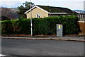
5
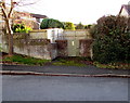
Llanbedr Road electricity substation, Crickhowell
The identifier on the Western Power Distribution electricity substation is LLANBEDR RD S/S 615328.
Image: © Jaggery
Taken: 19 Dec 2014
0.04 miles
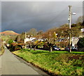
6
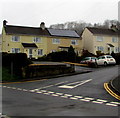
Derwen Fawr, Crickhowell
Houses in the cul-de-sac Derwen Fawr viewed across Llanbedr Road.
Image: © Jaggery
Taken: 19 Dec 2014
0.04 miles
7
Small trees lining Great Oak Road in Crickhowell
Is it a local sense of humour, or mere coincidence, that Great Oak Road is lined with trees that are not great (about 3 metres high or less). Or perhaps the trees were planted with the long term in mind...
Image: © Jaggery
Taken: 19 Dec 2014
0.05 miles
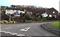
8
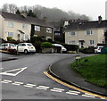
Northern junction of Llanbedr Road and Dan-y-grug, Crickhowell
Viewed from Oakfield Drive. The southern junction of Llanbedr Road and Dan-y-grug is 220 metres to the southwest.
Image: © Jaggery
Taken: 20 Jan 2019
0.05 miles
9
Llanbedr Road electricity substation, Crickhowell
The Western Power Distribution electricity substation is opposite Derwen Fawr. http://www.geograph.org.uk/photo/4289464
Image: © Jaggery
Taken: 19 Dec 2014
0.06 miles
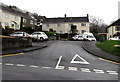
10

Houses above and below Great Oak Road, Crickhowell
Houses on the right are set slightly below road level.
Houses on the left are alongside a side road above a grassy bank.
Image: © Jaggery
Taken: 17 Feb 2019
0.07 miles