IMAGES TAKEN NEAR TO
Church Lane, CRICKHOWELL, NP8 1BB
Introduction
This page details the photographs taken nearby to Church Lane, NP8 1BB by members of the Geograph project.
The Geograph project started in 2005 with the aim of publishing, organising and preserving representative images for every square kilometre of Great Britain, Ireland and the Isle of Man.

There are currently over 7.5m images from over14,400 individuals and you can help contribute to the project by visiting https://www.geograph.org.uk
Image Map
Images are licensed for reuse under creativecommons.org/licenses/by-sa/2.0
Notes
- Clicking on the map will re-center to the selected point.
- The higher the marker number, the further away the image location is from the centre of the postcode.
Image Listing (572 Images Found)
Images are licensed for reuse under creativecommons.org/licenses/by-sa/2.0
Image
Details
Distance
1

Drinking fountain, Crickhowell
Located at the junction of High Street, Standard Street and Beaufort Street (the A40). It is probably some time since anyone drank here : the current use of the fountain is for a floral display.
Image: © Jaggery
Taken: 30 Jun 2010
0.01 miles
2

Crickhowell : corner of Standard Street and Beaufort Street
A view of part of the centre of Crickhowell, adjacent to the drinking fountainhttp://www.geograph.org.uk/photo/1949458 at the junction of three roads. This corner is occupied by Jehu's Stores.http://www.geograph.org.uk/photo/1215159
Image: © Jaggery
Taken: 30 Jun 2010
0.01 miles
3
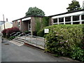
Crickhowell public library
Located in Silver Lane, part of the Powys County Council Library Service.
Image: © Jaggery
Taken: 17 Jun 2012
0.01 miles
4

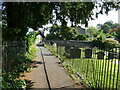
Entrance to Crickhowell Evangelical Church Centre
The entrance is from Silver Lane, near the library. http://www.geograph.org.uk/photo/3037515 Many of Crickhowell Evangelical Church's activities are based here in the Church Centre, the brick building behind the black fence at centre left.
Image: © Jaggery
Taken: 17 Jun 2012
0.01 miles
5

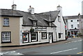
Bunting in High Street, Crickhowell
A view NNE along High Street from opposite the Dragon Inn. http://www.geograph.org.uk/photo/1102068
The long Diamond Jubilee weekend was at the start of June 2012, but as elsewhere in the UK, festive bunting remains a fortnight later.
Image: © Jaggery
Taken: 17 Jun 2012
0.01 miles
6

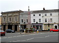
Grade II* listed Market Hall, Crickhowell
Located in High Street, built in 1833-1834 for the Duke of Beaufort. The building was originally both the town hall and a market. The upper rooms, in use as a magistrates' courtroom until the late 1980s, are now the Courtroom Cafe. On the ground floor, there are market stalls on several days a week.
The building was Grade II* listed in September 1983.
Image: © Jaggery
Taken: 17 Jun 2012
0.01 miles
7
Northern end of High Street, Crickhowell
Viewed from the corner of Standard Street. This is part of the area known as The Square or Market Square. In the foreground is a former drinking fountain. http://www.geograph.org.uk/photo/1949458 On the left is the Market Hall. http://www.geograph.org.uk/photo/3039916
Image: © Jaggery
Taken: 17 Jun 2012
0.01 miles
8
Bacchus, Crickhowell
Located at 1A Beaufort Street, at the edge of Market Square.
The independent off licence specialises in Welsh ales, ciders and spirits.
Image: © Jaggery
Taken: 17 Jun 2012
0.01 miles
9
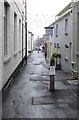
Silver Lane, Crickhowell
From High Street along Silver Lane towards Church Lane.
Cafe at Bookish is on the right.
https://www.geograph.org.uk/photo/6042617 to a closer view of the name sign.
Image: © Jaggery
Taken: 20 Jan 2019
0.01 miles