IMAGES TAKEN NEAR TO
Llanddewi Rhydderch, ABERGAVENNY, NP7 9UT
Introduction
This page details the photographs taken nearby to NP7 9UT by members of the Geograph project.
The Geograph project started in 2005 with the aim of publishing, organising and preserving representative images for every square kilometre of Great Britain, Ireland and the Isle of Man.

There are currently over 7.5m images from over14,400 individuals and you can help contribute to the project by visiting https://www.geograph.org.uk
Image Map
Images are licensed for reuse under creativecommons.org/licenses/by-sa/2.0
Notes
- Clicking on the map will re-center to the selected point.
- The higher the marker number, the further away the image location is from the centre of the postcode.
Image Listing (2 Images Found)
Images are licensed for reuse under creativecommons.org/licenses/by-sa/2.0
Image
Details
Distance
1
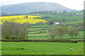
View west from near Poole House
The inhabitants of Poole House, and this pheasant, have a great view westwards towards Blorenge Image The white building in the middle distance delights in the name of Bannut-tree Image
Image: © Graham Horn
Taken: 13 Apr 2012
0.22 miles
2
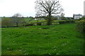
Towards Poole House
There are individual properties scattered around the rural lanes. This is one of them.
Image: © Graham Horn
Taken: 13 Apr 2012
0.23 miles