IMAGES TAKEN NEAR TO
Glanbaiden, ABERGAVENNY, NP7 9SE
Introduction
This page details the photographs taken nearby to Glanbaiden, NP7 9SE by members of the Geograph project.
The Geograph project started in 2005 with the aim of publishing, organising and preserving representative images for every square kilometre of Great Britain, Ireland and the Isle of Man.

There are currently over 7.5m images from over14,400 individuals and you can help contribute to the project by visiting https://www.geograph.org.uk
Image Map
Images are licensed for reuse under creativecommons.org/licenses/by-sa/2.0
Notes
- Clicking on the map will re-center to the selected point.
- The higher the marker number, the further away the image location is from the centre of the postcode.
Image Listing (40 Images Found)
Images are licensed for reuse under creativecommons.org/licenses/by-sa/2.0
Image
Details
Distance
1
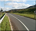
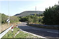
Heads of the Valleys road heading east for Abergavenny
The view along the eastbound carriageway of the A465.
Image: © Jaggery
Taken: 20 Oct 2010
0.09 miles
2
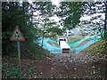
Replacement underpass
With the reduced clearance of the modern construction this underpass will presumably be for cattle.
Image: © Jennifer Luther Thomas
Taken: 27 Oct 2006
0.09 miles
4
Electricity pylon below the B4246 near Govilon
Located between the B4246 and the A465 Heads of the Valleys Road, one of many electricity pylons in this area.
Image: © Jaggery
Taken: 23 Jul 2017
0.11 miles
5
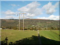
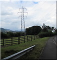
Power lines on western edge of King George's Field, near Govilon
In this area, there are both wooden posts, as seen here, and bigger, metal pylons, carrying power lines across fields. The fence on the right marks the edge of a recreation ground, King George's Field.
Image: © Jaggery
Taken: 20 Oct 2010
0.11 miles
6
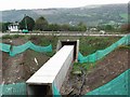
Glanbaiden Access Road
Side road leading to the small few homes in Glanbaiden. It was built during the early stages of the A465 widening. The small tunnel running under the A465 prior to widening was scrapped and a 5th exit was added to the new roundabout.
Image: © Luke Jones
Taken: 14 Sep 2022
0.12 miles
7
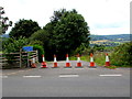
Coned-off side road near Govilon
On the north side of the B4246 viewed in July 2017.
Cones were here in October 2010. http://www.geograph.org.uk/photo/2123761
Image: © Jaggery
Taken: 23 Jul 2017
0.12 miles
8
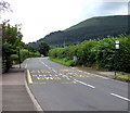
Hop Yard Lane bus stops near Govilon
The stops are on the B4246 west of Govilon. In July 2017, timetables on the bus stop pole on the left show Stagecoach in South Wales Route X4 and Route 3, both to Abergavenny.
SAFLE BWS on the road surface is Welsh for BUS STOP.
Image: © Jaggery
Taken: 23 Jul 2017
0.12 miles
9
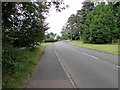
B4246 towards Govilon
The B4246 is here between the A465 Heads of the Valleys Road junction and the western boundary of Govilon.
Image: © Jaggery
Taken: 23 Jul 2017
0.12 miles
10
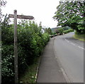
Public footpath signpost near Govilon
Pointing across the B4246 towards this http://www.geograph.org.uk/photo/5473777 public footpath to the Monmouthshire & Brecon Canal and the Usk Valley Walk.
Image: © Jaggery
Taken: 23 Jul 2017
0.13 miles