IMAGES TAKEN NEAR TO
Mill Lane, ABERGAVENNY, NP7 9SD
Introduction
This page details the photographs taken nearby to Mill Lane, NP7 9SD by members of the Geograph project.
The Geograph project started in 2005 with the aim of publishing, organising and preserving representative images for every square kilometre of Great Britain, Ireland and the Isle of Man.

There are currently over 7.5m images from over14,400 individuals and you can help contribute to the project by visiting https://www.geograph.org.uk
Image Map
Images are licensed for reuse under creativecommons.org/licenses/by-sa/2.0
Notes
- Clicking on the map will re-center to the selected point.
- The higher the marker number, the further away the image location is from the centre of the postcode.
Image Listing (4 Images Found)
Images are licensed for reuse under creativecommons.org/licenses/by-sa/2.0
Image
Details
Distance
1
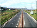
Heads of the Valleys Road heading west from Cadfor
Viewed from the farm access bridge. http://www.geograph.org.uk/photo/2160492
Image: © Jaggery
Taken: 22 Oct 2010
0.17 miles
3
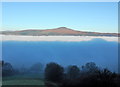
Sugar Loaf Mountain
A very frosty Winter morning. The mountain in the background is the Sugar Loaf Mountain. It stands 2 miles North West of Abergavenny. It's a very prominent landmark from all directions, it is 1961 feet high, so based on that I estimate this Radiation fog is 1600 feet thick.
Image: © RAY JONES
Taken: 20 Dec 2006
0.19 miles
4
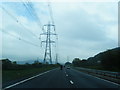
Roadworks along A465
This three lane stretch is being replaced by dual carriageway.
Image: © Jennifer Luther Thomas
Taken: 27 Oct 2006
0.21 miles