IMAGES TAKEN NEAR TO
Cwm Lane, ABERGAVENNY, NP7 9RY
Introduction
This page details the photographs taken nearby to Cwm Lane, NP7 9RY by members of the Geograph project.
The Geograph project started in 2005 with the aim of publishing, organising and preserving representative images for every square kilometre of Great Britain, Ireland and the Isle of Man.

There are currently over 7.5m images from over14,400 individuals and you can help contribute to the project by visiting https://www.geograph.org.uk
Image Map
Images are licensed for reuse under creativecommons.org/licenses/by-sa/2.0
Notes
- Clicking on the map will re-center to the selected point.
- The higher the marker number, the further away the image location is from the centre of the postcode.
Image Listing (4 Images Found)
Images are licensed for reuse under creativecommons.org/licenses/by-sa/2.0
Image
Details
Distance
1
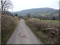
Lane in Cwm Llanwenarth
A narrow and winding country lane.
Image: © Jeremy Bolwell
Taken: 2 Mar 2013
0.20 miles
2
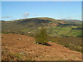
Cwm Llanwenarth
Looking down the north west flank of the Blorenge from the B4246 towards Cwm Farm. Bracken in the foreground.
Image: © M J Roscoe
Taken: 2 Aug 2019
0.23 miles