IMAGES TAKEN NEAR TO
Church Lane, ABERGAVENNY, NP7 9RP
Introduction
This page details the photographs taken nearby to Church Lane, NP7 9RP by members of the Geograph project.
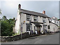
The Geograph project started in 2005 with the aim of publishing, organising and preserving representative images for every square kilometre of Great Britain, Ireland and the Isle of Man.

There are currently over 7.5m images from over14,400 individuals and you can help contribute to the project by visiting https://www.geograph.org.uk
Image Map
Images are licensed for reuse under creativecommons.org/licenses/by-sa/2.0
Notes
- Clicking on the map will re-center to the selected point.
- The higher the marker number, the further away the image location is from the centre of the postcode.
Image Listing (197 Images Found)
Images are licensed for reuse under creativecommons.org/licenses/by-sa/2.0
Image
Details
Distance
1
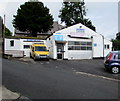
Govilon Garage, Church Lane, Govilon
Vehicle MOT and service centre.
Image: © Jaggery
Taken: 23 Jul 2017
0.01 miles
2
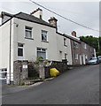
Hope House and Hope Cottages, Church Lane, Govilon
Hope House is in the foreground.
Image: © Jaggery
Taken: 23 Jul 2017
0.01 miles
3
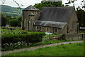
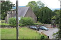
Christ Church, Govilon
Originally built in 1847 as a chapel of ease, it was enlarged into the parish church in 1860. Here the church is viewed from the towpath of the Monmouthshire and Brecon Canal.
Image: © Philip Halling
Taken: 23 May 2009
0.02 miles
4
The Bridgend Inn, Govilon
An old pub located in the centre of the village beside the stream.
Image: © Jeremy Bolwell
Taken: 2 Mar 2013
0.02 miles
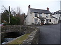
5
Tafarn y Bont, Govilon
Pub on the corner of Church Lane and Church Road, viewed in July 2017.
The pub was named Bridgend Inn in this http://www.geograph.org.uk/photo/1692109 October 2009 photo.
Image: © Jaggery
Taken: 23 Jul 2017
0.02 miles
7
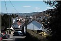
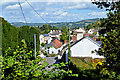
Govilon from the aqueduct
The Monmouthshire & Brecon Canal is carried over Church Lane at Govilon by a massively built aqueduct. This is a general view of the town taken from the canal towpath. The weather had finally got its act together and provided me with far more favourable conditions for photography than those I'd had for the previous two days!
Image: © John Winder
Taken: 24 Mar 2019
0.02 miles
8
Part of Govilon
Govilon is a smallish village but has varied topography and housing and businesses. This is or was Mapman's Dairy. The Blorenge looms over everything.
Image: © Jeremy Bolwell
Taken: 2 Mar 2013
0.03 miles
9
Boaters' view of Christ Church, Govilon
View of parish church from aqueduct Image; the OS map shows the canal going under Church Lane, but the lane goes through a tunnel under the canal!
Image: © M J Roscoe
Taken: 13 Jul 2019
0.03 miles
10
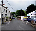
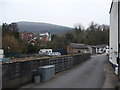
Up Church Lane, Govilon
Church Lane ascends towards Christ Church past Govilon Garage http://www.geograph.org.uk/photo/5472857 on the right.
Image: © Jaggery
Taken: 23 Jul 2017
0.03 miles