IMAGES TAKEN NEAR TO
Station Road, ABERGAVENNY, NP7 9RF
Introduction
This page details the photographs taken nearby to Station Road, NP7 9RF by members of the Geograph project.
The Geograph project started in 2005 with the aim of publishing, organising and preserving representative images for every square kilometre of Great Britain, Ireland and the Isle of Man.

There are currently over 7.5m images from over14,400 individuals and you can help contribute to the project by visiting https://www.geograph.org.uk
Image Map
Images are licensed for reuse under creativecommons.org/licenses/by-sa/2.0
Notes
- Clicking on the map will re-center to the selected point.
- The higher the marker number, the further away the image location is from the centre of the postcode.
Image Listing (210 Images Found)
Images are licensed for reuse under creativecommons.org/licenses/by-sa/2.0
Image
Details
Distance
1
Ignore Satnav sign, Penybont, Govilon, Monmouthshire
The wordless sign facing Merthyr Road indicates that drivers of heavy goods
vehicles should ignore what satnav is telling them and use another route.
Image: © Jaggery
Taken: 17 Sep 2023
0.01 miles
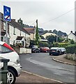
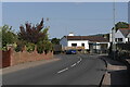
2
Down Station Road, Govilon
Station Road descend towards Merthyr Road past the right turn into Penybont. http://www.geograph.org.uk/photo/5474115
Image: © Jaggery
Taken: 23 Jul 2017
0.01 miles
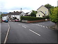
3
Junction of Station Road and Merthyr Road, Govilon
The blue sign on the left tells HGV drivers to ignore satnav directions -
Station Road is unsuitable for heavy goods vehicles.
Image: © Jaggery
Taken: 23 Jul 2017
0.01 miles
4
Bilingual street name sign, Govilon, Monmouthshire
The sign facing Merthyr Road shows that the street
named Penybont in English is Pen y Bont in Welsh.
Image: © Jaggery
Taken: 17 Sep 2023
0.01 miles
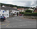
5
Village Centre, B4246
The main road going through Govilon. The B4246 was once part of the A465.
Image: © Luke Jones
Taken: 14 Sep 2022
0.01 miles
6
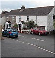
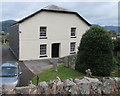
Walnut Tree Cottages, Station Road, Govilon
Near the B4246 Merthyr Road junction (ahead).
Image: © Jaggery
Taken: 23 Jul 2017
0.01 miles
7
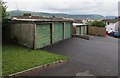
Six lockup garages, Station Road, Govilon
Opposite the Penybont junction. http://www.geograph.org.uk/photo/5474115
Image: © Jaggery
Taken: 23 Jul 2017
0.02 miles
8

Penybont, Govilon
Penybont (Pen Y Bont in Welsh) is a cul-de-sac on the east side of Station Road.
Image: © Jaggery
Taken: 23 Jul 2017
0.03 miles
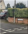
9
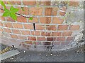
Ordnance Survey Cut Mark
This OS cut mark can be found on the wall south side of the road. It marks a point 102.388m above mean sea level.
Image: © Adrian Dust
Taken: 9 Jun 2023
0.03 miles
10
South side of Llanwenarth Baptist Chapel, Govilon
Viewed from the Monmouthshire & Brecon Canal.
http://www.geograph.org.uk/photo/5474195 to a view of the north side and some details.
The building was Grade II (star) listed in 1994.
Image: © Jaggery
Taken: 23 Jul 2017
0.05 miles