IMAGES TAKEN NEAR TO
Ty Clyd Close, ABERGAVENNY, NP7 9PJ
Introduction
This page details the photographs taken nearby to Ty Clyd Close, NP7 9PJ by members of the Geograph project.
The Geograph project started in 2005 with the aim of publishing, organising and preserving representative images for every square kilometre of Great Britain, Ireland and the Isle of Man.

There are currently over 7.5m images from over14,400 individuals and you can help contribute to the project by visiting https://www.geograph.org.uk
Image Map
Images are licensed for reuse under creativecommons.org/licenses/by-sa/2.0
Notes
- Clicking on the map will re-center to the selected point.
- The higher the marker number, the further away the image location is from the centre of the postcode.
Image Listing (78 Images Found)
Images are licensed for reuse under creativecommons.org/licenses/by-sa/2.0
Image
Details
Distance
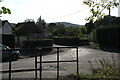
1
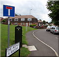
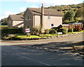
Along The Avenue, Govilon
The Avenue (Y Rhodfa in Welsh) leads to Maeshyfryd.
A dark green BT telecoms cabinet http://www.geograph.org.uk/photo/5473298 is in the foreground.
Image: © Jaggery
Taken: 23 Jul 2017
0.08 miles
2
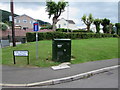
BT telecoms cabinet, The Avenue, Govilon
Located near the corner of Merthyr Road, viewed in July 2017.
The cabinet is not in a July 2011 Google Earth Street View.
The sign shows that The Avenue is Y Rhodfa in Welsh.
Image: © Jaggery
Taken: 23 Jul 2017
0.10 miles
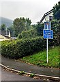
3
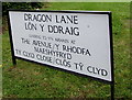
Large bilingual street name sign on a Govilon corner
The English/Welsh sign faces Merthyr Road. The grey back of the sign is on the left here. http://www.geograph.org.uk/photo/5473298
Image: © Jaggery
Taken: 23 Jul 2017
0.10 miles
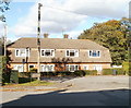
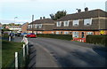
4
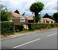
Houses in The Avenue, Govilon
The houses are on the north side of, and set slightly below, the B4246 Merthyr Road.
Image: © Jaggery
Taken: 23 Jul 2017
0.11 miles
5
Mill Lane / Dragon Lane
End of Mill Lane, leading onto Dragon Lane, at the very bottom of Govilon.
Image: © Luke Jones
Taken: 14 Sep 2022
0.11 miles
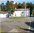
6
No access to canal, Govilon, Monmouthshire
Referring to Elms Road https://www.geograph.org.uk/photo/7600575 the sign facing the B4246 has English and Welsh text.
Image: © Jaggery
Taken: 17 Sep 2023
0.11 miles
7
Dragon Lane, Govilon
Houses on Dragon Lane viewed from the B4246.
Image: © Jaggery
Taken: 20 Oct 2010
0.12 miles
8
Bus shelter at the eastern edge of Govilon
The bus shelter is adjacent to houses on the corner of Dragon Lane and Merthyr Road (B4246).
Image: © Jaggery
Taken: 20 Oct 2010
0.12 miles
9
Corner of Elms Road and Merthyr Road, Govilon
The houses are near the eastern edge of Govilon.
Image: © Jaggery
Taken: 20 Oct 2010
0.12 miles
10
The Avenue, Govilon
Houses on the north side of The Avenue, on the eastern edge of Govilon.
Image: © Jaggery
Taken: 22 Oct 2010
0.13 miles