IMAGES TAKEN NEAR TO
Llanfoist, ABERGAVENNY, NP7 9NS
Introduction
This page details the photographs taken nearby to NP7 9NS by members of the Geograph project.
The Geograph project started in 2005 with the aim of publishing, organising and preserving representative images for every square kilometre of Great Britain, Ireland and the Isle of Man.

There are currently over 7.5m images from over14,400 individuals and you can help contribute to the project by visiting https://www.geograph.org.uk
Image Map
Images are licensed for reuse under creativecommons.org/licenses/by-sa/2.0
Notes
- Clicking on the map will re-center to the selected point.
- The higher the marker number, the further away the image location is from the centre of the postcode.
Image Listing (162 Images Found)
Images are licensed for reuse under creativecommons.org/licenses/by-sa/2.0
Image
Details
Distance
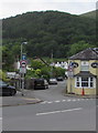
1
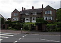
New Villas, Llanfoist
New Villas is the name of this row of houses set back from,
and slightly above, the south side of the B4246 Merthyr Road.
Image: © Jaggery
Taken: 11 Jun 2017
0.00 miles
2
Merthyr Road telecoms cabinet, Llanfoist
A different shade of green from the surrounding vegetation.
The Kiln Road junction is on the right.
Image: © Jaggery
Taken: 11 Jun 2017
0.01 miles
3
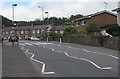
Zebra crossing, Merthyr Road, Llanfoist
Across the B4246 Merthyr Road. The Cutting junction is ahead on the right.
Image: © Jaggery
Taken: 11 Jun 2017
0.01 miles
4
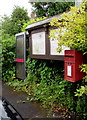
Communications area on a Llanfoist corner
Three communications facilities - postbox, village noticeboard and phonebox,
are alongside the B4246 Merthyr Road near the corner of Kiln Road.
Image: © Jaggery
Taken: 11 Jun 2017
0.01 miles
5
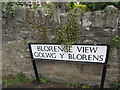
Blorenge View/Golwg y Blorens name sign, Llanfoist
The English/Welsh sign faces Merthyr Road near the corner of The Cutting.
Image: © Jaggery
Taken: 11 Jun 2017
0.02 miles
6
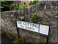
The Cutting/Yr Hafn name sign, Llanfoist
The English/Welsh sign is at the SW end of The Cutting, near the corner of Merthyr Road.
Image: © Jaggery
Taken: 11 Jun 2017
0.02 miles
7
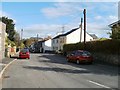
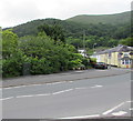
The Cutting, Llanfoist
Houses along this road known as The Cutting date from the 1860s. They were built as workers' cottages at the time of the construction of the Merthyr, Tredegar and Abergavenny Railway in 1862.
Image: © Jaggery
Taken: 22 Oct 2010
0.03 miles
8
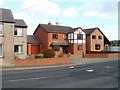
Modern houses, Llanfoist
Located on Merthyr Road, opposite the post office. http://www.geograph.org.uk/photo/2177882
Image: © Jaggery
Taken: 22 Oct 2010
0.03 miles
9
Kiln Road junction, Llanfoist
The northeast end of Kiln Road viewed across the B4246 Merthyr Road.
Signs show a one-way street and 7.5 tonnes vehicle weight limit, except for access.
Spice Lounge http://www.geograph.org.uk/photo/5429767 is on the right.
Image: © Jaggery
Taken: 11 Jun 2017
0.03 miles
10
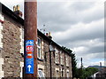
Cycle Across The Beacons sign, The Cutting, Llanfoist
Below (National Cycle Network route) 46, the orange part of the sign shows
CYCLE ACROSS THE (BRECON) BEACONS.
The Cutting is a residential cul-de-sac extending for 300 metres from Merthyr Road
to an underpass (for walkers and cyclists) beneath the A465 Heads of the Valleys Road.
Image: © Jaggery
Taken: 11 Jun 2017
0.03 miles