IMAGES TAKEN NEAR TO
Gypsy Lane, ABERGAVENNY, NP7 9LS
Introduction
This page details the photographs taken nearby to Gypsy Lane, NP7 9LS by members of the Geograph project.
The Geograph project started in 2005 with the aim of publishing, organising and preserving representative images for every square kilometre of Great Britain, Ireland and the Isle of Man.

There are currently over 7.5m images from over14,400 individuals and you can help contribute to the project by visiting https://www.geograph.org.uk
Image Map
Images are licensed for reuse under creativecommons.org/licenses/by-sa/2.0
Notes
- Clicking on the map will re-center to the selected point.
- The higher the marker number, the further away the image location is from the centre of the postcode.
Image Listing (134 Images Found)
Images are licensed for reuse under creativecommons.org/licenses/by-sa/2.0
Image
Details
Distance
1
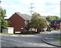
St Faith's Close, Llanfoist
Modern houses viewed from the corner of Gipsy Lane.
Image: © Jaggery
Taken: 22 Oct 2010
0.05 miles
2
Warning sign - Patrol/Hebryngwr, Gypsy Lane, Llanfoist
The English/Welsh sign faces the B4269 Gypsy Lane on the approach to the village primary school.
Image: © Jaggery
Taken: 11 Jun 2017
0.07 miles
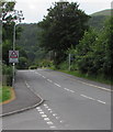
3
Your speed indicator, Merthyr Road, Llanfoist
Facing westbound traffic on the B4246 Merthyr Road. The display is green if
an approaching vehicle is within the speed limit, as here, or red if over the speed limit.
Image: © Jaggery
Taken: 11 Jun 2017
0.08 miles
4
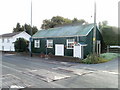
Llanfoist Post Office
Previously located nearby in The Cutting, Llanfoist Post Office is now in Llanfoist Church Hall, Merthyr Road. A sign on the right points to Llanfoist OAP Hall http://www.geograph.org.uk/photo/2177892.
Image: © Jaggery
Taken: 22 Oct 2010
0.08 miles
5

Llanfoist OAP Hall
Located along an unnamed lane a few metres south of the post office. http://www.geograph.org.uk/photo/2177882
Among the groups who meet here regularly are Castle Quilters and Llanfoist Poultry and Game Group.
Image: © Jaggery
Taken: 22 Oct 2010
0.08 miles
6
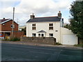
Llanfoist Cottage
A cottage in Llanfoist named Llanfoist Cottage, located on the north side of Merthyr Road (B4246).
Image: © Jaggery
Taken: 22 Oct 2010
0.08 miles
7

Junction of Gipsy Lane and Merthyr Road, Llanfoist
The view along the northern end of Gipsy Lane. Ahead, turn left for Govilon (1½ miles) or right for Abergavenny (1 mile). The sign pointing towards Gipsy Lane shows Llanellen 2 miles.
Image: © Jaggery
Taken: 22 Oct 2010
0.08 miles
8

Scenic view on approaching Llanfoist from the NE
Looking into Llanfoist along Merthyr Road. Just behind the camera is the Heads of the Valleys (A465) roundabout. On the right is the turning into Llanfoist Depot. http://www.geograph.org.uk/photo/2178004
In the distance is the high ground of The Blorenge Image (peak 1,841 feet or 561 metres)
Image: © Jaggery
Taken: 22 Oct 2010
0.08 miles
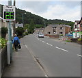
9
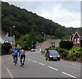
Sunday morning cyclists in Llanfoist
Cycling westwards on the B4246 Merthyr Road.
Image: © Jaggery
Taken: 11 Jun 2017
0.08 miles
10
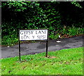
Bilingual lane name sign in Llanfoist
The sign on the right here http://www.geograph.org.uk/photo/5429257 shows that Gypsy Lane is Lôn y Sipsi in Welsh.
Image: © Jaggery
Taken: 11 Jun 2017
0.08 miles