IMAGES TAKEN NEAR TO
Clos Hengaer Ysgol, ABERGAVENNY, NP7 9JZ
Introduction
This page details the photographs taken nearby to Clos Hengaer Ysgol, NP7 9JZ by members of the Geograph project.
The Geograph project started in 2005 with the aim of publishing, organising and preserving representative images for every square kilometre of Great Britain, Ireland and the Isle of Man.

There are currently over 7.5m images from over14,400 individuals and you can help contribute to the project by visiting https://www.geograph.org.uk
Image Map
Images are licensed for reuse under creativecommons.org/licenses/by-sa/2.0
Notes
- Clicking on the map will re-center to the selected point.
- The higher the marker number, the further away the image location is from the centre of the postcode.
Image Listing (171 Images Found)
Images are licensed for reuse under creativecommons.org/licenses/by-sa/2.0
Image
Details
Distance
1
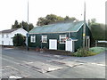
Llanfoist Post Office
Previously located nearby in The Cutting, Llanfoist Post Office is now in Llanfoist Church Hall, Merthyr Road. A sign on the right points to Llanfoist OAP Hall http://www.geograph.org.uk/photo/2177892.
Image: © Jaggery
Taken: 22 Oct 2010
0.04 miles
2

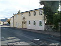
Llanfoist OAP Hall
Located along an unnamed lane a few metres south of the post office. http://www.geograph.org.uk/photo/2177882
Among the groups who meet here regularly are Castle Quilters and Llanfoist Poultry and Game Group.
Image: © Jaggery
Taken: 22 Oct 2010
0.04 miles
3
Spice Lounge, Llanfoist
Bar, restaurant and takeaway located on the corner of Merthyr Road and Kiln Road.
Formerly named Exotic East, the premises were for many decades the Llanfoist Inn.
Image: © Jaggery
Taken: 22 Oct 2010
0.04 miles
4
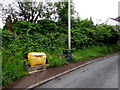
Yellow box and dark green bin, Kiln Road, Llanfoist
The salt/grit box is alongside a litter bin.
Image: © Jaggery
Taken: 11 Jun 2017
0.05 miles
5
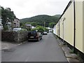
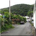
Kiln Road, Llanfoist
From the corner of Merthyr Road along Kiln Road towards Llanellen Road.
Image: © Jaggery
Taken: 11 Jun 2017
0.05 miles
6

One-way sign, Kiln Road, Llanfoist
The white arrow on a blue background shows the direction of travel for vehicles on Kiln Road.
Image: © Jaggery
Taken: 11 Jun 2017
0.05 miles
7
One-way sign, Kiln Road, Llanfoist
The white arrow on a blue background shows the direction of travel for vehicles on Kiln Road.
Image: © Jaggery
Taken: 11 Jun 2017
0.06 miles
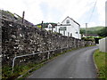
8
Ty Gwyn, Kiln Road, Llanfoist
The white house is alongside Kiln Road. Ty Gwyn is Welsh for White House.
Image: © Jaggery
Taken: 11 Jun 2017
0.06 miles
9
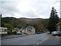
Part of Merthyr Road, Llanfoist below the Blorenge
The building here was a pub, but is now an Indian restaurant called the Spice Lounge.
Image: © Jeremy Bolwell
Taken: 28 Oct 2012
0.07 miles
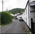
10
Long wall and handrail, Kiln Road, Llanfoist
On the ascent to Llanellen Road.
Image: © Jaggery
Taken: 11 Jun 2017
0.07 miles