IMAGES TAKEN NEAR TO
The Paddock, ABERGAVENNY, NP7 9HJ
Introduction
This page details the photographs taken nearby to The Paddock, NP7 9HJ by members of the Geograph project.
The Geograph project started in 2005 with the aim of publishing, organising and preserving representative images for every square kilometre of Great Britain, Ireland and the Isle of Man.

There are currently over 7.5m images from over14,400 individuals and you can help contribute to the project by visiting https://www.geograph.org.uk
Image Map
Images are licensed for reuse under creativecommons.org/licenses/by-sa/2.0
Notes
- Clicking on the map will re-center to the selected point.
- The higher the marker number, the further away the image location is from the centre of the postcode.
Image Listing (55 Images Found)
Images are licensed for reuse under creativecommons.org/licenses/by-sa/2.0
Image
Details
Distance
1
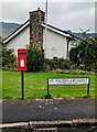
Queen Elizabeth II postbox, St Helen's Crescent, Llanellen, Monmouthshire
The adjacent sign shows
ST HELEN'S CRESCENT
17 - 49 ODD NO'S ONLY
Image: © Jaggery
Taken: 17 Sep 2023
0.08 miles
2
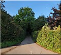
Hedge-lined lane, Llanellen, Monmouthshire
Viewed from the B4269.
Image: © Jaggery
Taken: 3 Sep 2023
0.13 miles
3
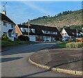
Houses and hillside, Llanellen, Monmouthshire
Looking along St Helen's Crescent from the B4269.
Image: © Jaggery
Taken: 3 Sep 2023
0.13 miles
4
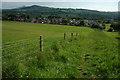
View of Llanellen and Usk Valley
View of the village of Llanellen from the Usk Valley Walk from below the Monmouthshire and Brecon Canal. On the horizon to the left is the wooded Ysgyryd Fach and behind the higher Ysgyryd Fawr (Skirrid).
Image: © Philip Halling
Taken: 23 May 2009
0.15 miles
5
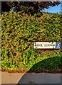
Welsh-only name sign, Heol Gerrig, Llanellen, Monmouthshire
The sign facing the B4269 shows that Heol Gerrig is not a through route.
Image: © Jaggery
Taken: 3 Sep 2023
0.16 miles
6
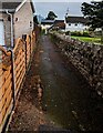
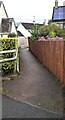
Path past the edge of the churchyard, Llanellen, Monmouthshire
The stone wall is at the perimeter of St Helen's churchyard.
Image: © Jaggery
Taken: 17 Sep 2023
0.16 miles
7
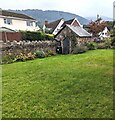
Small building in a corner of the churchyard, Llanellen, Monmouthshire
In the NW corner of St Helen's churchyard in the Church in Wales Diocese of Monmouth.
Image: © Jaggery
Taken: 17 Sep 2023
0.16 miles
8
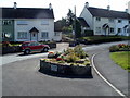
Floral triangle, Llanellen
Located at the junction of St Helen's Crescent and the B4269. A plaque records that the village won the Best Kept Village (Gwent) award in 1987 1989 1990 and 1991, and was second placed in Wales in 1990.
Image: © Jaggery
Taken: 14 Sep 2011
0.17 miles
9
Path away from the churchyard, Llanellen, Monmouthshire
Behind the camera for St Helen's churchyard in the Church in Wales Diocese of Monmouth.
Image: © Jaggery
Taken: 17 Sep 2023
0.17 miles
10
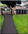
Wheelie bins and a litter bin, Llanellen, Monmouthshire
In September 2023 a litter bin and four wheelie bins are near an exit
from St Helen's churchyard in the Church in Wales Diocese of Monmouth.
Image: © Jaggery
Taken: 17 Sep 2023
0.17 miles