IMAGES TAKEN NEAR TO
Llanellen, ABERGAVENNY, NP7 9HF
Introduction
This page details the photographs taken nearby to NP7 9HF by members of the Geograph project.
The Geograph project started in 2005 with the aim of publishing, organising and preserving representative images for every square kilometre of Great Britain, Ireland and the Isle of Man.

There are currently over 7.5m images from over14,400 individuals and you can help contribute to the project by visiting https://www.geograph.org.uk
Image Map
Images are licensed for reuse under creativecommons.org/licenses/by-sa/2.0
Notes
- Clicking on the map will re-center to the selected point.
- The higher the marker number, the further away the image location is from the centre of the postcode.
Image Listing (24 Images Found)
Images are licensed for reuse under creativecommons.org/licenses/by-sa/2.0
Image
Details
Distance
1
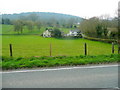
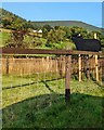
View west from Pant
Looking up the western side of the Usk Valley from the B4269 between Llanellen and Llanfoist.
On the hillside, above the unseen Monmouthshire and Brecon canal is Ffrwd Wood.
Image: © Jonathan Billinger
Taken: 19 Apr 2010
0.02 miles
2
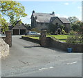
Y Pant Farm farmhouse north of Llanellen
Viewed from the B4269. Y Pant Farm is on the west side of the River Usk.
Image: © Jaggery
Taken: 14 Sep 2011
0.04 miles
3
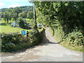
Road to two farms north of Llanellen
Viewed from the B4269. The road leads to Glen Rosa Farm, some buildings of which are in view on the left, and to Bridge Farm near the Monmouthshire & Brecon canal, about 300 metres away.
Image: © Jaggery
Taken: 14 Sep 2011
0.06 miles
4
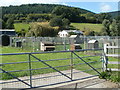
Local Delight Farm Shop north of Llanellen
This view shows the southern side of the farm shop site, located at Sunnyside, on the west side of the B4269. Items for sale include fresh meat, free range eggs, ice cream, freshly baked bread, jams & preserves, fruit, vegetables and locally made cheese.
Image: © Jaggery
Taken: 14 Sep 2011
0.09 miles
5
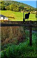
Farm animal silhouette in rural Monmouthshire
Alongside the B4269 in September 2023.
Image: © Jaggery
Taken: 3 Sep 2023
0.10 miles
6
Sheep silhouette in rural Monmouthshire
Alongside the B4269 between Llanellen and Llanfoist.
Image: © Jaggery
Taken: 3 Sep 2023
0.10 miles
7
Rural view to Ysgyryd Fach
The small cone of Little Skirrid seen from the B4269 between Llanellen and Llanfoist.
Image: © Jonathan Billinger
Taken: 19 Apr 2010
0.10 miles
8
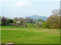
View across paddock
In the distance is Blorenge, a hill at the southeastern edge of the Brecon Beacons National Park.
Image: © Alan Hughes
Taken: 27 Sep 2018
0.10 miles
9
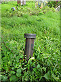
GWR boundary post
In a field adjacent to towpath. GWR bought the MonBrec canal in 1880. Most of these posts were dated to 1917 - 1920. Usually sited in the vicinity of bridges or to protect the area around the outflow of spillwiers.
Inscription: Great Western Railway Cᴼs // BOUNDARY / ?
Milestone Society National ID: MON_GWRFOI03em
Image: © Mr Red
Taken: 12 May 2021
0.14 miles
10
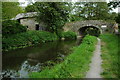
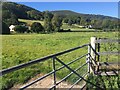
Bridge 93, Monmouthshire and Brecon Canal
Bridge 93 on the Monmouthshire and Brecon Canal and adjacent traditional stone-built barn near Llanellen.
Image: © Philip Halling
Taken: 23 May 2009
0.14 miles