IMAGES TAKEN NEAR TO
Llanfoist, ABERGAVENNY, NP7 9HE
Introduction
This page details the photographs taken nearby to NP7 9HE by members of the Geograph project.
The Geograph project started in 2005 with the aim of publishing, organising and preserving representative images for every square kilometre of Great Britain, Ireland and the Isle of Man.

There are currently over 7.5m images from over14,400 individuals and you can help contribute to the project by visiting https://www.geograph.org.uk
Image Map
Images are licensed for reuse under creativecommons.org/licenses/by-sa/2.0
Notes
- Clicking on the map will re-center to the selected point.
- The higher the marker number, the further away the image location is from the centre of the postcode.
Image Listing (15 Images Found)
Images are licensed for reuse under creativecommons.org/licenses/by-sa/2.0
Image
Details
Distance
1
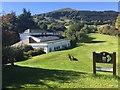
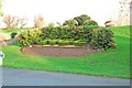
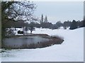
Monmouthshire Golf Club
View of the clubhouse from the first tee with Blorenge in the distance.
Image: © Alan Hughes
Taken: 27 Sep 2018
0.00 miles
3
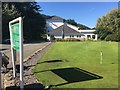
Putting green
Practice putting green at Monmouthshire Golf Club.
Image: © Alan Hughes
Taken: 27 Sep 2018
0.02 miles
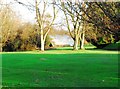
5
Monmouthshire Golf Course
18 hole golf course set in a beautiful part of the South Valleys. In the early twentieth century a part of the golf course was also the local airstrip. It was used by many of the aviation pioneers. One of the hangars still exists today and is used to store general golf course machinery.
Image: © RAY JONES
Taken: 1 Jan 2007
0.05 miles
6
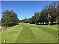
1st hole at Monmouthshire Golf Club
View down the fairway from the 1st tee at Monmouthshire Golf Club.
Image: © Alan Hughes
Taken: 27 Sep 2018
0.08 miles
7
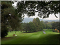
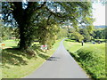
Monmouthshire Golf course
Monmouthshire Golf course as seen from close to the entrance from the B4269 south of Llanfoist.
Image: © Trevor Littlewood
Taken: 14 Oct 2016
0.10 miles
8
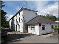
Monmouthshire Golf Course
One of the old aircraft hangars still exists today. Now used for storage of general golf course machinery.
Image: © RAY JONES
Taken: 1 Jan 2007
0.11 miles
10
Proceed at your own risk, Monmouthshire Golf Club
A sign on the entrance road from the B4269 states
STOP
LOOK FOR GOLFERS HITTING BALLS ACROSS THE ROAD. PROCEED AT YOUR OWN RISK.
Monmouthshire Golf Club is located south of Llanfoist and north of Llanellen, between the B4269 and the River Usk. Before golf was played here, the land was for many years the home of the Monmouthshire races which lasted several days each year and drew large crowds of spectators. Racecourse Farm still exists today, on the north side of the course. The Monmouthshire Golf Club was founded in 1892 as a 9 hole course, extended to 18 holes in 1938.
Image: © Jaggery
Taken: 14 Sep 2011
0.15 miles