IMAGES TAKEN NEAR TO
Crawshay Close, ABERGAVENNY, NP7 9FF
Introduction
This page details the photographs taken nearby to Crawshay Close, NP7 9FF by members of the Geograph project.
The Geograph project started in 2005 with the aim of publishing, organising and preserving representative images for every square kilometre of Great Britain, Ireland and the Isle of Man.

There are currently over 7.5m images from over14,400 individuals and you can help contribute to the project by visiting https://www.geograph.org.uk
Image Map
Images are licensed for reuse under creativecommons.org/licenses/by-sa/2.0
Notes
- Clicking on the map will re-center to the selected point.
- The higher the marker number, the further away the image location is from the centre of the postcode.
Image Listing (77 Images Found)
Images are licensed for reuse under creativecommons.org/licenses/by-sa/2.0
Image
Details
Distance
1
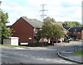
St Faith's Close, Llanfoist
Modern houses viewed from the corner of Gipsy Lane.
Image: © Jaggery
Taken: 22 Oct 2010
0.11 miles
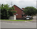
2
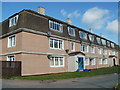
Grove Mansions, Llanfoist
Grove Mansions occupy two 3-storey buildings on Grove Avenue. In view is the larger of the buildings, containing 12 flats. The other six flats are beyond the right edge of the view.
Image: © Jaggery
Taken: 14 Sep 2011
0.12 miles
3
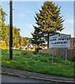
Bilingual Welcome sign, Llanfoist, Monmouthshire
The sign shows that Llanfoist is Llan-ffwyst in Welsh.
Image: © Jaggery
Taken: 3 Sep 2023
0.13 miles
4
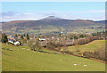
Llanfoist
View over Llanfoist from a field footpath.
Image: © Wayland Smith
Taken: 1 Feb 2015
0.15 miles
5

Llanfoist OAP Hall
Located along an unnamed lane a few metres south of the post office. http://www.geograph.org.uk/photo/2177882
Among the groups who meet here regularly are Castle Quilters and Llanfoist Poultry and Game Group.
Image: © Jaggery
Taken: 22 Oct 2010
0.15 miles
6
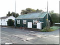
Llanfoist Post Office
Previously located nearby in The Cutting, Llanfoist Post Office is now in Llanfoist Church Hall, Merthyr Road. A sign on the right points to Llanfoist OAP Hall http://www.geograph.org.uk/photo/2177892.
Image: © Jaggery
Taken: 22 Oct 2010
0.15 miles
7
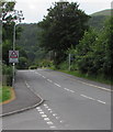
Warning sign - Patrol/Hebryngwr, Gypsy Lane, Llanfoist
The English/Welsh sign faces the B4269 Gypsy Lane on the approach to the village primary school.
Image: © Jaggery
Taken: 11 Jun 2017
0.15 miles
8
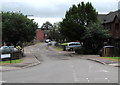
St Faith's Close, Llanfoist
Cul-de-sac on the east side of the B4269 Gypsy Lane.
Image: © Jaggery
Taken: 11 Jun 2017
0.16 miles
9
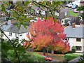
Autumn tree in Llanfoist
Viewed from the canal towpath above Llanfoist.
Image: © Jeremy Bolwell
Taken: 28 Oct 2012
0.16 miles
10
Electricity substation below a Llanfoist corner
The grey cabinet below the corner of St Faith's Close and Gypsy Lane is a
Western Power Distribution electricity substation. Its identifier is GYPSY LANE S/S 53-4001.
Image: © Jaggery
Taken: 11 Jun 2017
0.17 miles