IMAGES TAKEN NEAR TO
Pencroesoped, ABERGAVENNY, NP7 9EN
Introduction
This page details the photographs taken nearby to Pencroesoped, NP7 9EN by members of the Geograph project.
The Geograph project started in 2005 with the aim of publishing, organising and preserving representative images for every square kilometre of Great Britain, Ireland and the Isle of Man.

There are currently over 7.5m images from over14,400 individuals and you can help contribute to the project by visiting https://www.geograph.org.uk
Image Map
Images are licensed for reuse under creativecommons.org/licenses/by-sa/2.0
Notes
- Clicking on the map will re-center to the selected point.
- The higher the marker number, the further away the image location is from the centre of the postcode.
Image Listing (59 Images Found)
Images are licensed for reuse under creativecommons.org/licenses/by-sa/2.0
Image
Details
Distance
1
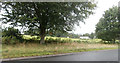
Farmland between Llanover and Pencroesoped
Image: © John Lord
Taken: 28 Aug 2020
0.02 miles
2
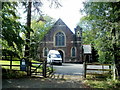
Llanover Retreat
Set back from the west side of Old Abergavenny Road, Llanover.
The name sign shows LLANOVER RETREAT PRESBYTERIAN CHURCH OF WALES.
Llanover Retreat is available for use by church and community groups.
Image: © Jaggery
Taken: 14 Sep 2011
0.04 miles
3
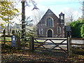
Old church at Llanover
Now billed as the Llanover Retreat.
Image: © Jeremy Bolwell
Taken: 18 Nov 2012
0.04 miles
4
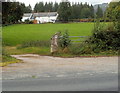
Track from the A4042 to Old Abergavenny Road near Llanover
The 150 metre long track leads to houses in Old Abergavenny Road.
Image: © Jaggery
Taken: 22 Sep 2011
0.08 miles
5
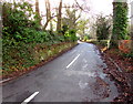
Old Abergavenny Road, Llanover
Ascending from the A4042. This way to Pencroesoped, Goytre Wharf and Mamhilad.
Image: © Jaggery
Taken: 26 Dec 2017
0.10 miles
6
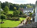
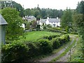
Whitewashed houses at Llanover
A small, attractive cluster of houses which can be viewed from the A4042. See also Image
Image: © Robin Drayton
Taken: 10 Sep 2008
0.11 miles
7
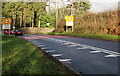
Crocodile teeth markings on the A4042 near Llanover
Painted white triangles draw attention to the reduction in the speed limit ahead.
Image: © Jaggery
Taken: 26 Dec 2017
0.11 miles
8
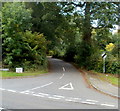
Old Abergavenny Road, Llanover
In Llanover, the unclassified Old Abergavenny Road from Mamhilad,
formerly a main route, joins the present-day main road to Abergavenny, the A4042.
Image: © Jaggery
Taken: 22 Sep 2011
0.11 miles
9
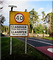
Llanover - Please drive carefully
The National Speed Limit on the A4042 drops to 40mph through Llanover (Llanofer in Welsh).
Image: © Jaggery
Taken: 26 Dec 2017
0.11 miles
10
The southern end of Llanover village
An area of scattered houses in a small valley through which runs the Rhyd-y-Meirch stream which means ‘Ford of the Stallions’.
Image: © Robin Drayton
Taken: 10 Sep 2008
0.11 miles