IMAGES TAKEN NEAR TO
Nantyderry, ABERGAVENNY, NP7 9DP
Introduction
This page details the photographs taken nearby to NP7 9DP by members of the Geograph project.
The Geograph project started in 2005 with the aim of publishing, organising and preserving representative images for every square kilometre of Great Britain, Ireland and the Isle of Man.

There are currently over 7.5m images from over14,400 individuals and you can help contribute to the project by visiting https://www.geograph.org.uk
Image Map
Images are licensed for reuse under creativecommons.org/licenses/by-sa/2.0
Notes
- Clicking on the map will re-center to the selected point.
- The higher the marker number, the further away the image location is from the centre of the postcode.
Image Listing (7 Images Found)
Images are licensed for reuse under creativecommons.org/licenses/by-sa/2.0
Image
Details
Distance
1
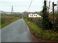
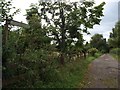
Nant-y-derry Road
Looking east towards the Usk.
A footpath heads south at this point.
Image: © Jonathan Billinger
Taken: 14 Dec 2009
0.03 miles
2
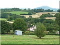
Heathfield, in the Nant y Robwl valley
Seen from Star Road.
Image: © Christine Johnstone
Taken: 13 Sep 2013
0.09 miles
3
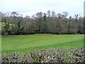
Nant y Robwl meadows
View north from Nant-y-derry Road.
Image: © Jonathan Billinger
Taken: 14 Dec 2009
0.09 miles
4
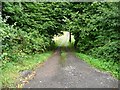
Steep access track, north of the Nant-y-derry road
Dropping into the Nant y Robwl valley.
Image: © Christine Johnstone
Taken: 13 Sep 2013
0.13 miles
5
Path to Mill Farm at the junction with the road to Nant-y-Derry
Image: © David Gearing
Taken: 14 Sep 2012
0.13 miles
6
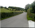
Star Road heads towards Penperlleni
This is a typical hedge-lined road in rural Monmouthshire. Viewed from crossroads near Chain Bridge.
Image: © Jaggery
Taken: 30 Jun 2011
0.22 miles
7
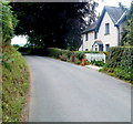
Greenmeadow farmhouse near Goytre
Star Road passes the farmhouse located on the southern side of the farm.
Image: © Jaggery
Taken: 30 Jun 2011
0.22 miles