1
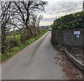
Road towards Lower Pentwyn Farm, Nantyderry
A sign on the wall shows that this is not a through road.
Image: © Jaggery
Taken: 10 Apr 2022
0.02 miles
2
Public bridleway to Pen-twyn
Also a farm access track, running east from the railway bridge at Nant-y-derry.
Image: © Christine Johnstone
Taken: 13 Sep 2013
0.03 miles
3
Nantyderry Cottages
A row of 4 cottages located on the east side of The Foxhunter. http://www.geograph.org.uk/photo/3532505
Image: © Jaggery
Taken: 22 Sep 2011
0.04 miles
4
7-bar field gate, Nantyderry
At the entrance to this https://www.geograph.org.uk/photo/7143874 field.
Image: © Jaggery
Taken: 10 Apr 2022
0.05 miles
5
Foxhunter Inn information board, Nantyderry, Monmouthshire
The board on the wall here https://www.geograph.org.uk/photo/7143852 in April 2022 shows
REAL ALE • HOME COOKED FOOD • BEER GARDEN
Image: © Jaggery
Taken: 10 Apr 2022
0.05 miles
6
Vehicle tracks across farmland
Seen from the field gate, north-east of the railway bridge at Nant-y-derry.
Image: © Christine Johnstone
Taken: 13 Sep 2013
0.06 miles
7
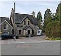
The Foxhunter restaurant, Nantyderry
Built as a railway stationmaster's house, part of Nantyderry station where passenger services ceased in 1958. Its later uses include tearooms and a pub. The Foxhunter was named after the horse ridden by Nantyderry local, Sir Harry Llewellyn, in the 1952 Helsinki Olympic Games. After Foxhunter won the only British gold medal of the games, the pub was renamed in his honour.
Foxhunter is buried in the nearby hills. http://www.geograph.org.uk/photo/2775556
Image: © Jaggery
Taken: 22 Sep 2011
0.06 miles
8
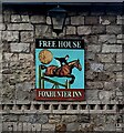
Foxhunter Inn name sign, Nantyderry, Monmouthshire
On the wall here. https://www.geograph.org.uk/photo/7143852 Foxhunter was the horse ridden by Nantyderry local, Sir Harry Llewellyn, in the 1952 Helsinki Olympic Games. After Foxhunter won the only British gold medal of the games, the inn was renamed.
Image: © Jaggery
Taken: 10 Apr 2022
0.06 miles
9
Grade II Listed Foxhunter Inn, Nantyderry
In April 2022 a blackboard outside the Foxhunter in rural Monmouthshire shows "BAR OPEN ALL DAY". Cadw records that Nantyderry station was built nearby by the Newport, Abergavenny and Hereford Railway in 1854 and was worked at first by the London and North Western Railway. It became a part of the West Midland Railway in 1860 and the Great Western Railway in 1863. This building was the stationmaster's house, built at the same time as the station. When the station closed in 1958 it was converted to an inn and extensions were built. Grade II Listed in 2001 for its special interest as part of a group of railway buildings near the former Nantyderry station.
Image: © Jaggery
Taken: 10 Apr 2022
0.06 miles
10
Partly grassed field, Nantyderry
Viewed from this https://www.geograph.org.uk/photo/7143870 gate in rural Monmouthshire in April 2022.
Image: © Jaggery
Taken: 10 Apr 2022
0.06 miles


