IMAGES TAKEN NEAR TO
Llanvair Cross, ABERGAVENNY, NP7 9DE
Introduction
This page details the photographs taken nearby to NP7 9DE by members of the Geograph project.
The Geograph project started in 2005 with the aim of publishing, organising and preserving representative images for every square kilometre of Great Britain, Ireland and the Isle of Man.

There are currently over 7.5m images from over14,400 individuals and you can help contribute to the project by visiting https://www.geograph.org.uk
Image Map
Images are licensed for reuse under creativecommons.org/licenses/by-sa/2.0
Notes
- Clicking on the map will re-center to the selected point.
- The higher the marker number, the further away the image location is from the centre of the postcode.
Image Listing (8 Images Found)
Images are licensed for reuse under creativecommons.org/licenses/by-sa/2.0
Image
Details
Distance
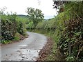
1
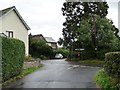
Croes Llanvair from the west
At the 88 metre spot height.
Image: © Christine Johnstone
Taken: 13 Sep 2013
0.01 miles
2
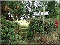
Entrance to the Pen-twyn footpath, at Croes Llanvair
The road and footpath signposts seem to be having a bit of a tussle.
Image: © Christine Johnstone
Taken: 13 Sep 2013
0.02 miles
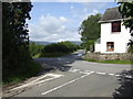
3
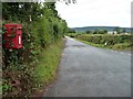
Postbox at Llanvair
South-west of the crossroads, with Cefn Cottage in the distance.
Image: © Christine Johnstone
Taken: 13 Sep 2013
0.02 miles
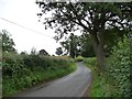
4
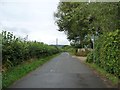
The road to Llanover
Heading west from Croes Llanvair.
Image: © Christine Johnstone
Taken: 13 Sep 2013
0.03 miles
5
The road to Llanfair Kilgeddin
Running south-east from Croes Llanvair.
Image: © Christine Johnstone
Taken: 13 Sep 2013
0.04 miles
7
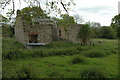
Ruined barn
Ruined barn near Llanfair Cross.
Image: © Philip Halling
Taken: 2 May 2009
0.16 miles
8
The road to Croes Llanvair
Looking south-east to the 69 metre spot height.
Image: © Christine Johnstone
Taken: 13 Sep 2013
0.24 miles