IMAGES TAKEN NEAR TO
Llanellen, ABERGAVENNY, NP7 9BU
Introduction
This page details the photographs taken nearby to NP7 9BU by members of the Geograph project.
The Geograph project started in 2005 with the aim of publishing, organising and preserving representative images for every square kilometre of Great Britain, Ireland and the Isle of Man.

There are currently over 7.5m images from over14,400 individuals and you can help contribute to the project by visiting https://www.geograph.org.uk
Image Map
Images are licensed for reuse under creativecommons.org/licenses/by-sa/2.0
Notes
- Clicking on the map will re-center to the selected point.
- The higher the marker number, the further away the image location is from the centre of the postcode.
Image Listing (18 Images Found)
Images are licensed for reuse under creativecommons.org/licenses/by-sa/2.0
Image
Details
Distance
1
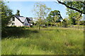
Rushy meadow, The Larches
Damp roadside meadow with buttercups.
Image: © M J Roscoe
Taken: 8 Jun 2021
0.03 miles
2
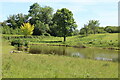
Pond, Upper House
Pond with clump of flags beside minor road.
Image: © M J Roscoe
Taken: 8 Jun 2021
0.14 miles
3
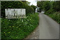
Old road sign, Llanellen
Old road sign on a country road entering Llanellen.
Image: © Philip Halling
Taken: 2 May 2009
0.18 miles
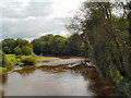
4
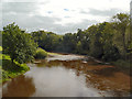
River Usk from Llanellen Bridge
Looking downstream from Llanellen Bridge.
Image: © David Dixon
Taken: 30 Aug 2012
0.20 miles
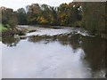
7
River Usk, Llanellen
Looking downstream from Llanellen Bridge
Image: © David Dixon
Taken: 30 Aug 2012
0.21 miles
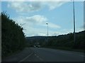
8

A4042 11 miles from Cwmbran
Viewed from the B4269 in Llanellen.
Image: © Jaggery
Taken: 27 Aug 2023
0.21 miles
9
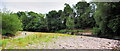
River Usk low water at Llanellen Bridge
Very low water in the River Usk, just a few yards downstream from Llanellen Bridge. The children are walking on the stoney river bed , which is normally covered by several metres in rainier times. A stark comparison to http://www.geograph.org.uk/photo/294524 and http://www.geograph.org.uk/photo/294521 both taken only a few miles upstream during a flood
Image: © RAY JONES
Taken: 3 Jul 2010
0.21 miles
10
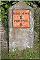
Old Milestone by the A4042, Llanellen
Stone with iron plate by the A4042, in parish of Llanfoist Fawr (Monmouthshire District), south of village, on grass verge, opposite B4269 junction, in front of boundary wall of Bryn Garth, East side of road.
Inscription reads:- : ABERGAVENNY / 2 / PONTYPOOL / 8 :
Surveyed
Milestone Society National ID: MON_AGPP02.
Image: © Milestone Society
Taken: Unknown
0.21 miles