IMAGES TAKEN NEAR TO
Langpen Drive, ABERGAVENNY, NP7 9AX
Introduction
This page details the photographs taken nearby to Langpen Drive, NP7 9AX by members of the Geograph project.
The Geograph project started in 2005 with the aim of publishing, organising and preserving representative images for every square kilometre of Great Britain, Ireland and the Isle of Man.

There are currently over 7.5m images from over14,400 individuals and you can help contribute to the project by visiting https://www.geograph.org.uk
Image Map
Images are licensed for reuse under creativecommons.org/licenses/by-sa/2.0
Notes
- Clicking on the map will re-center to the selected point.
- The higher the marker number, the further away the image location is from the centre of the postcode.
Image Listing (91 Images Found)
Images are licensed for reuse under creativecommons.org/licenses/by-sa/2.0
Image
Details
Distance
1
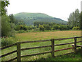
View across the Usk to The Blorenge
For geological information about the mountain, see http://en.wikipedia.org/wiki/The_Blorenge
Image: © Pauline E
Taken: 18 Jul 2009
0.04 miles
2
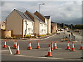
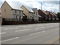
Cooper Way, Llanfoist near Abergavenny
Houses nearing completion on Cooper Way, part of a development of 150 new houses on the site of the former Cooper's Filters works. The development faces the Waitrose superstore http://www.geograph.org.uk/photo/2157519 on the opposite side of Merthyr Road (A4143).
The location is just south of the southern edge of Abergavenny.
Image: © Jaggery
Taken: 22 Oct 2010
0.08 miles
3
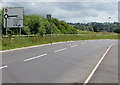
Transfer station direction sign, Llanfoist
On the approach to this https://www.geograph.org.uk/photo/6140026 roundabout, the sign shows that Transfer station is Gorsaf drosglwyddo in Welsh.
Image: © Jaggery
Taken: 11 Jun 2017
0.09 miles
4
Cooper Way, Llanfoist
21st century houses on the site formerly occupied by Cooper's Filters works on the east side of Merthyr Road.
Image: © Jaggery
Taken: 11 Jun 2017
0.09 miles
5
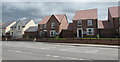
New houses in Llanfoist
Viewed across the A4143 Merthyr Road in June 2017.
Image: © Jaggery
Taken: 11 Jun 2017
0.10 miles
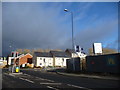
6
Recently-built houses, Sanders Heights, Llanfoist
Viewed across the A4143 Merthyr Road in June 2017.
Image: © Jaggery
Taken: 11 Jun 2017
0.10 miles
7
Pelican crossing on the approach to Premier Inn, Llanfoist
A Premier Inn and Brewers Fayre https://www.geograph.org.uk/photo/6140026 are in the background.
Image: © Jaggery
Taken: 11 Jun 2017
0.10 miles
8
New housing development at Llanfoist
David Wilson Homes development on Johnsey Estates land, previously occupied by the old and demolished Cooper's Filters factory site. Opposite Waitrose.
Image: © Jeremy Bolwell
Taken: 9 Dec 2012
0.10 miles
9
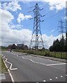
Electricity pylons near Premier Inn, Llanfoist
A Premier Inn and Brewers Fayre https://www.geograph.org.uk/photo/6140026 are in the background.
Image: © Jaggery
Taken: 11 Jun 2017
0.10 miles
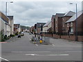
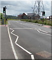
10
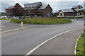
Grassy roundabout, Westgate, Llanfoist
Brewers Fayre is on the right. The Premier Inn on the left is being built in July 2017.
Image: © Jaggery
Taken: 11 Jun 2017
0.10 miles