IMAGES TAKEN NEAR TO
Hardwick, ABERGAVENNY, NP7 9AA
Introduction
This page details the photographs taken nearby to NP7 9AA by members of the Geograph project.
The Geograph project started in 2005 with the aim of publishing, organising and preserving representative images for every square kilometre of Great Britain, Ireland and the Isle of Man.

There are currently over 7.5m images from over14,400 individuals and you can help contribute to the project by visiting https://www.geograph.org.uk
Image Map
Images are licensed for reuse under creativecommons.org/licenses/by-sa/2.0
Notes
- Clicking on the map will re-center to the selected point.
- The higher the marker number, the further away the image location is from the centre of the postcode.
Image Listing (24 Images Found)
Images are licensed for reuse under creativecommons.org/licenses/by-sa/2.0
Image
Details
Distance
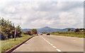
1

View along the B4598 towards the Sugarloaf, near Abergavenny
Image: © Ruth Sharville
Taken: 3 Mar 2014
0.01 miles
2
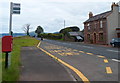
Postbox and Horse and Jockey bus stop, Hardwick
The bus stop sign alongside Old Raglan Road (the B4598) shows Horse and Jockey.
This is doubly confusing for visitors. The cottage opposite is not the Horse and Jockey, which is the name of a former pub 200 metres behind the camera, now The Hardwick restaurant. http://www.geograph.org.uk/photo/3041838
Image: © Jaggery
Taken: 15 Jul 2012
0.02 miles
4
View to Garn Clochdy
From beside the B4598.
Image: © Oast House Archive
Taken: 19 Aug 2013
0.04 miles
5
NW on A40 nearing Abergavenny, 1993
Straight ahead is the prominent Sugar Loaf (1,955 ft.).
Image: © Ben Brooksbank
Taken: 1 Jun 1993
0.10 miles
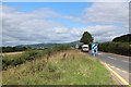
6
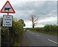
Watch out for cows in the road ahead, Old Raglan Road
The sign is alongside the B4598 on the approach from Abergavenny to The Hardwick. http://www.geograph.org.uk/photo/3041838
The tree on the right is leafless in mid-July.
Image: © Jaggery
Taken: 15 Jul 2012
0.10 miles
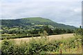
7
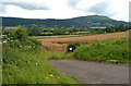
Hardwick field with a distant view of the Blorenge
The field is near this bus stop http://www.geograph.org.uk/photo/3041931 alongside Old Raglan Road (B4598). The view is across the River Usk valley towards distant high ground, dominated by the Blorenge Image peak 561 metres (1841 feet).
Image: © Jaggery
Taken: 15 Jul 2012
0.11 miles
8
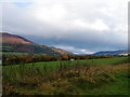
The Usk Valley
The vehicle in view is on the A40 dual carriageway.
Image: © John Lucas
Taken: 12 Nov 2001
0.11 miles
9
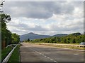
The A40 south-east of Abergavenny
Looking north-west from a lay-by on the A40. An older road which once carried the same designation runs parallel to it a little to the north-east, and is now known as the B4598. The skyline is dominated by Pen y Fâl/the Sugarloaf, a mountain which has an even finer profile when seen from the east.
Stuart Wilding's Image is a shot taken from a position just across the railway line to the west.
Image: © Stefan Czapski
Taken: 19 Jun 2011
0.11 miles
10
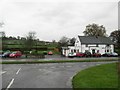
The Hardwick
On the B4598. With Ty'r pwll Farm behind.
Image: © Jennifer Luther Thomas
Taken: 17 Nov 2006
0.13 miles