IMAGES TAKEN NEAR TO
Skenfrith, ABERGAVENNY, NP7 8UH
Introduction
This page details the photographs taken nearby to NP7 8UH by members of the Geograph project.
The Geograph project started in 2005 with the aim of publishing, organising and preserving representative images for every square kilometre of Great Britain, Ireland and the Isle of Man.

There are currently over 7.5m images from over14,400 individuals and you can help contribute to the project by visiting https://www.geograph.org.uk
Image Map
Images are licensed for reuse under creativecommons.org/licenses/by-sa/2.0
Notes
- Clicking on the map will re-center to the selected point.
- The higher the marker number, the further away the image location is from the centre of the postcode.
Image Listing (492 Images Found)
Images are licensed for reuse under creativecommons.org/licenses/by-sa/2.0
Image
Details
Distance
1
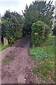
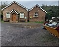
Private drive to Melrose, Skenfrith, Monmouthshire
The village hall https://www.geograph.org.uk/photo/7438667 is near the camera.
Image: © Jaggery
Taken: 6 Nov 2022
0.02 miles
2
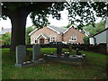
Skenfrith Village Hall
Currently the village hall for Skenfrith, this building was originally built as the National School back in 1843. Viewed from the churchyard at St. Bridget's Church.
Image: © Fabian Musto
Taken: 29 Aug 2018
0.03 miles
3
Former school, Skenfrith
Now the Parish Hall.
Image: © Jonathan Thacker
Taken: 14 Sep 2018
0.03 miles
4
Skenfrith Village Hall
Currently the village hall for Skenfrith, this building was originally built as the National School back in 1843.
Image: © Fabian Musto
Taken: 29 Aug 2018
0.03 miles
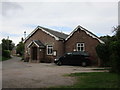
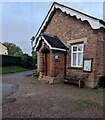
5
SE side of Skenfrith Village Hall, Monmouthshire
A tablet https://www.geograph.org.uk/photo/1190058 over the hall entrance records that the building was erected in 1843 as a National School.
Image: © Jaggery
Taken: 6 Nov 2022
0.03 miles
6
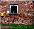
Yellow box on a wall of Skenfrith Village Hall, Monmouthshire
The box located here https://www.geograph.org.uk/photo/7438667 contains a defibrillator. The small notice near the window shows
PARKING STRICTLY FOR HALL AND CHURCH USE ONLY.
Image: © Jaggery
Taken: 6 Nov 2022
0.03 miles
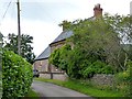
7
Monmow Villa (Skenfrith)
Here is Monmow Villa at Skenfrith, which is viewed from the churchyard at St. Bridget's Church.
Image: © Fabian Musto
Taken: 29 Aug 2018
0.03 miles
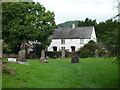
8
The Old Vicarage, Skenfrith
This attractive building was formerly the vicarage for St Bridget's Church.
Image: © Richard Green
Taken: 13 Jul 2012
0.03 miles
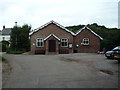
9
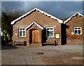
Skenfrith village hall
The early Victorian building dates from 1843, http://www.geograph.org.uk/photo/1190058 constructed as a National School.
The main hall can seat up to 100 people. There is also a meeting room.
Image: © Jaggery
Taken: 22 Jan 2012
0.03 miles
10
Wooden benches, Skenfrith, Monmouthshire
Located here https://www.geograph.org.uk/photo/7438667 the benches are alongside the village hall entrance.
Image: © Jaggery
Taken: 6 Nov 2022
0.03 miles