IMAGES TAKEN NEAR TO
Llantilio Crossenny, ABERGAVENNY, NP7 8TH
Introduction
This page details the photographs taken nearby to NP7 8TH by members of the Geograph project.
The Geograph project started in 2005 with the aim of publishing, organising and preserving representative images for every square kilometre of Great Britain, Ireland and the Isle of Man.

There are currently over 7.5m images from over14,400 individuals and you can help contribute to the project by visiting https://www.geograph.org.uk
Image Map
Images are licensed for reuse under creativecommons.org/licenses/by-sa/2.0
Notes
- Clicking on the map will re-center to the selected point.
- The higher the marker number, the further away the image location is from the centre of the postcode.
Image Listing (6 Images Found)
Images are licensed for reuse under creativecommons.org/licenses/by-sa/2.0
Image
Details
Distance
1
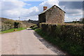
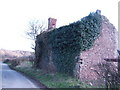
Dilapidated cottage
This roadside dilapidated cottage appears to have been re-roofed since it was previously photographed by Jonathan Billinger. See Image]
Image: © Philip Halling
Taken: 27 Apr 2013
0.09 miles
3
Three Castles Walk
According to the OS map, Three Castles Walk takes a direct route across the field, though a sign indicates it follows this track.
Image: © Philip Halling
Taken: 27 Apr 2013
0.11 miles
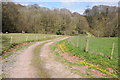
5
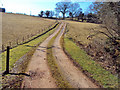
Track to Tump Farm
Emerging from Llyfos Wood and joining the lane at the top of this field.
Image: © Trevor Rickard
Taken: 5 Mar 2010
0.12 miles
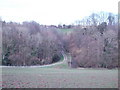
6
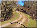
Track entering Llyfos Wood
Farm track heading north-east through a narrow strip of woodland.
Image: © Trevor Rickard
Taken: 5 Mar 2010
0.16 miles