IMAGES TAKEN NEAR TO
Llantilio Crossenny, ABERGAVENNY, NP7 8TG
Introduction
This page details the photographs taken nearby to NP7 8TG by members of the Geograph project.
The Geograph project started in 2005 with the aim of publishing, organising and preserving representative images for every square kilometre of Great Britain, Ireland and the Isle of Man.

There are currently over 7.5m images from over14,400 individuals and you can help contribute to the project by visiting https://www.geograph.org.uk
Image Map
Images are licensed for reuse under creativecommons.org/licenses/by-sa/2.0
Notes
- Clicking on the map will re-center to the selected point.
- The higher the marker number, the further away the image location is from the centre of the postcode.
Image Listing (8 Images Found)
Images are licensed for reuse under creativecommons.org/licenses/by-sa/2.0
Image
Details
Distance
1
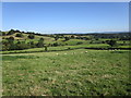
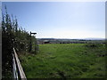
Grass fields around Lower Cwm
Lower Cwm is near the centre of the picture but largely hidden.
Image: © Jonathan Thacker
Taken: 18 Sep 2019
0.03 miles
2
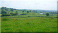
View east over Lower Cwm
Multispan polytunnels in the valley to the right.
Image: © Jonathan Billinger
Taken: 7 Jun 2016
0.15 miles
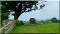
4
Middle Cwm Farm
View across farmland to Middle Cwm Farm.
Image: © Philip Halling
Taken: 13 Dec 2014
0.20 miles
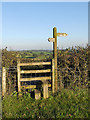
5
Finger post indicating the Three Castles Walk near Middle Cwm Farm
Image: © Jonathan Thacker
Taken: 18 Sep 2019
0.21 miles
7
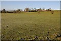
Relaxing sheep
Who can blame them on this fine June morning?
Image: © Jonathan Billinger
Taken: 7 Jun 2016
0.22 miles
8
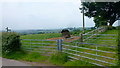
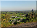
Three Castles Walk
The point where the path heads west towards White Castle near Middle Cwm Farm.
Image: © Jonathan Billinger
Taken: 7 Jun 2016
0.22 miles