IMAGES TAKEN NEAR TO
ABERGAVENNY, NP7 8TA
Introduction
This page details the photographs taken nearby to NP7 8TA by members of the Geograph project.
The Geograph project started in 2005 with the aim of publishing, organising and preserving representative images for every square kilometre of Great Britain, Ireland and the Isle of Man.

There are currently over 7.5m images from over14,400 individuals and you can help contribute to the project by visiting https://www.geograph.org.uk
Image Map
Images are licensed for reuse under creativecommons.org/licenses/by-sa/2.0
Notes
- Clicking on the map will re-center to the selected point.
- The higher the marker number, the further away the image location is from the centre of the postcode.
Image Listing (6 Images Found)
Images are licensed for reuse under creativecommons.org/licenses/by-sa/2.0
Image
Details
Distance
1
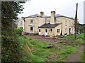
Old Treadam
House dating back from the 17th century, passed by the Offa's Dyke National Trail
Image: © Chris Heaton
Taken: 9 May 2006
0.04 miles
2
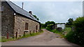
Offa's Dyke Path at Tre-Adam
Traditional sandstone farm buildings.
Image: © Jonathan Billinger
Taken: 7 Jun 2016
0.08 miles
3
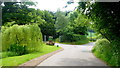
Entrance at Treadam
The sign is for The Hog's Head, a pub/restaurant/wedding and function venue in converted farm buildings.
See; http://www.hogsheadpub.co.uk/
Image: © Jonathan Billinger
Taken: 7 Jun 2016
0.09 miles
4
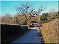
Lane into Treadam
Heading north with the entrance to the well-hidden Hogs Head pub just ahead on the right.
Image: © Trevor Rickard
Taken: 5 Mar 2010
0.10 miles
5
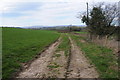
Farmland track
Farmland track near Great Treadam in the Trothy valley.
Image: © Philip Halling
Taken: 15 Mar 2014
0.13 miles
6
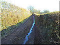
Offa's Dyke Path north of Treadam
View south along a stretch of farm track with high hedges on either side. Must be one of the most boring parts of this long distance footpath.
Image: © Trevor Rickard
Taken: 5 Mar 2010
0.22 miles