IMAGES TAKEN NEAR TO
Llantilio Crossenny, ABERGAVENNY, NP7 8SS
Introduction
This page details the photographs taken nearby to NP7 8SS by members of the Geograph project.
The Geograph project started in 2005 with the aim of publishing, organising and preserving representative images for every square kilometre of Great Britain, Ireland and the Isle of Man.

There are currently over 7.5m images from over14,400 individuals and you can help contribute to the project by visiting https://www.geograph.org.uk
Image Map
Images are licensed for reuse under creativecommons.org/licenses/by-sa/2.0
Notes
- Clicking on the map will re-center to the selected point.
- The higher the marker number, the further away the image location is from the centre of the postcode.
Image Listing (9 Images Found)
Images are licensed for reuse under creativecommons.org/licenses/by-sa/2.0
Image
Details
Distance
1
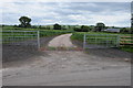
Entrance to Pen-twyn
Entrance and driveway to Pen-twyn.
Image: © Philip Halling
Taken: 9 Jun 2012
0.11 miles
2
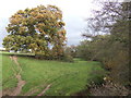
Oak tree by the Trothy
A final flourish of autumn colour.
Image: © Jonathan Billinger
Taken: 8 Nov 2007
0.17 miles
3
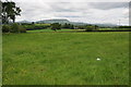
View to the Black Mountains
View to the Black Mountains with the Sugar Loaf on the left and Skirrid in the centre. The main eastern escarpment of the Black Mountains can be seen to the right.
Image: © Philip Halling
Taken: 9 Jun 2012
0.19 miles
4
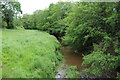
The River Trothy
The River Trothy viewed from Llwyn-deri Bridge.
Image: © Philip Halling
Taken: 9 Jun 2012
0.21 miles
5
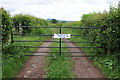
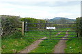
'This gate to be shut...'
A request to please shut this gate on a green road near Wernrheolydd.
Image: © Philip Halling
Taken: 9 Jun 2012
0.23 miles
6
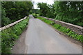
Llwyn-deri Bridge
The Llwyn Deri bridge crosses the River Trothy.
Image: © Philip Halling
Taken: 9 Jun 2012
0.23 miles
8
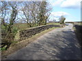
Please keep gate shut at all times
Well, I had no cause to open it. Even though the route is shown as one of those white roads with green dots "another route with public access". This is interesting because it is also a no through route.
Image: © Graham Horn
Taken: 13 Apr 2012
0.25 miles
9
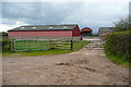
Croes-y-giach
The buildings of this tidy farm.
Image: © Graham Horn
Taken: 13 Apr 2012
0.25 miles