IMAGES TAKEN NEAR TO
Firs Road, ABERGAVENNY, NP7 8SL
Introduction
This page details the photographs taken nearby to Firs Road, NP7 8SL by members of the Geograph project.
The Geograph project started in 2005 with the aim of publishing, organising and preserving representative images for every square kilometre of Great Britain, Ireland and the Isle of Man.

There are currently over 7.5m images from over14,400 individuals and you can help contribute to the project by visiting https://www.geograph.org.uk
Image Map
Images are licensed for reuse under creativecommons.org/licenses/by-sa/2.0
Notes
- Clicking on the map will re-center to the selected point.
- The higher the marker number, the further away the image location is from the centre of the postcode.
Image Listing (47 Images Found)
Images are licensed for reuse under creativecommons.org/licenses/by-sa/2.0
Image
Details
Distance
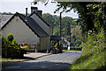
1

Up Firs Road, Llanvapley, Monmouthshire
Firs Road ascends to the north, away from the B4233, the main road through Llanvapley.
Image: © Jaggery
Taken: 11 Aug 2024
0.04 miles
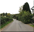
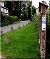
2

Firs Road, Llanvapley, Monmouthshire
Hedge-lined road on the north side of the B4233, the main road through the village.
Image: © Jaggery
Taken: 20 Sep 2020
0.05 miles
3
West along the B4233, Llanvapley, Monmouthshire
The B4233 is the main road through the village. Ahead for Abergavenny.
Image: © Jaggery
Taken: 20 Sep 2020
0.05 miles
4
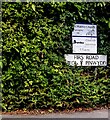
Bilingual Firs Road name sign, Llanvapley, Monmouthshire
The sign facing the B4233 shows FIRS ROAD and the Welsh HEOL Y PINWYDD.
Information for the nearby St Mabli's Church is above the name sign.
Image: © Jaggery
Taken: 11 Aug 2024
0.05 miles
5
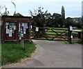
Noticeboard and gate, Llanvapley, Monmouthshire
Set back from the south side of the B4233, at the entrance to Llanvapley Recreation Ground.
Image: © Jaggery
Taken: 20 Sep 2020
0.06 miles
6
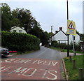
Warning sign - Blind junction, Llanvapley, Monmouthshire
Alongside the B4233, the main road through the village.
Image: © Jaggery
Taken: 20 Sep 2020
0.06 miles
7
Use Hand Sanitiser, Llanvapley, Monmouthshire
Viewed in September 2020 during the Coronavirus (COVID-19) pandemic.
A hand sanitiser dispenser is on the right edge of the noticeboard here. https://www.geograph.org.uk/photo/6612501
Image: © Jaggery
Taken: 20 Sep 2020
0.06 miles
8
The Red Hart Inn, Llanvapley
Closed by the owners in 2002, to the dismay of the villagers I met. Monmouthshire County Council and the Welsh Assembly have both turned down applications to turn it into a private house.
Image: © Stuart Wilding
Taken: 9 Sep 2014
0.06 miles
9
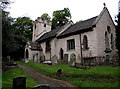
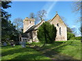
Grade II (Star) Listed church in Llanvapley, Monmouthshire
Part of the Church in Wales Diocese of Monmouth, the parish church of Llanvapley is dedicated to St Mabli (or Mapley). Restored in 1861 and 1950, the Old Red Sandstone church in the Early English style dates from the 15th century. Grade II (Star) Listed as a well-preserved medieval parish church with a fine tower.
Image: © Jaggery
Taken: 20 Sep 2020
0.06 miles