IMAGES TAKEN NEAR TO
Old Monmouth Road, ABERGAVENNY, NP7 8SA
Introduction
This page details the photographs taken nearby to Old Monmouth Road, NP7 8SA by members of the Geograph project.
The Geograph project started in 2005 with the aim of publishing, organising and preserving representative images for every square kilometre of Great Britain, Ireland and the Isle of Man.

There are currently over 7.5m images from over14,400 individuals and you can help contribute to the project by visiting https://www.geograph.org.uk
Image Map
Images are licensed for reuse under creativecommons.org/licenses/by-sa/2.0
Notes
- Clicking on the map will re-center to the selected point.
- The higher the marker number, the further away the image location is from the centre of the postcode.
Image Listing (5 Images Found)
Images are licensed for reuse under creativecommons.org/licenses/by-sa/2.0
Image
Details
Distance
2
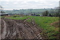
Tyre tracks in the earth
Tyre tracks in the soft earth near Mynachdy Farm, Llanddewi Rhydderch.
Image: © Philip Halling
Taken: 14 Jan 2012
0.06 miles
3
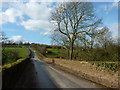
Mynachdy Bridge, near Llanddewi Rhydderch
Image: © Ruth Sharville
Taken: 16 Feb 2014
0.08 miles
4
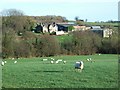
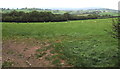
Farmland near Llanddewi Rhydderch
View across farmland and New House Farm near Llanddewi Rhydderch. Sugar Loaf can be seen in the distance.
Image: © Philip Halling
Taken: 14 Jan 2012
0.10 miles
5
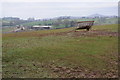
Distant sheep in a field in rural Monmouthshire
Viewed from a field gate on the south side of the B4233 Mynachdy Pitch in September 2020.
Image: © Jaggery
Taken: 20 Sep 2020
0.25 miles