IMAGES TAKEN NEAR TO
Cross Ash, ABERGAVENNY, NP7 8PU
Introduction
This page details the photographs taken nearby to NP7 8PU by members of the Geograph project.
The Geograph project started in 2005 with the aim of publishing, organising and preserving representative images for every square kilometre of Great Britain, Ireland and the Isle of Man.

There are currently over 7.5m images from over14,400 individuals and you can help contribute to the project by visiting https://www.geograph.org.uk
Image Map
Images are licensed for reuse under creativecommons.org/licenses/by-sa/2.0
Notes
- Clicking on the map will re-center to the selected point.
- The higher the marker number, the further away the image location is from the centre of the postcode.
Image Listing (6 Images Found)
Images are licensed for reuse under creativecommons.org/licenses/by-sa/2.0
Image
Details
Distance
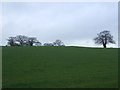
2
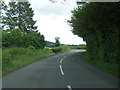
Old Ross Road (B4521) towards Skenfrith
Looking north east.
Image: © JThomas
Taken: 4 Apr 2019
0.18 miles
3
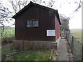
Cross Ash Telephone Exchange
Situated on the B4521 road, this dark wooden building is a common sight in rural areas and has a BT warning notice with wording in both English and Welsh. It has the code SWZKA and provides telephone and broadband services to 208 residential and 42 non-residential premises in Cross Ash, plus Bont, Llangattock Lingoed and Llanvetherine nearby. The numbering range of this TE is (01873) 821xxx, the (01873) referring to the Abergavenny group of eight TEs, and its postcode is NP7 8PU.
Image: © David Hillas
Taken: 10 Feb 2017
0.19 miles
6
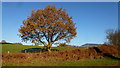
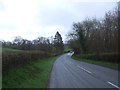
Young oak tree
Opposite Hill House by the Old Ross Road, B4521.
The top of St. Edmunds Tump can be seen in the distance.
Image: © Jonathan Billinger
Taken: 29 Nov 2016
0.22 miles