IMAGES TAKEN NEAR TO
Cross Ash, ABERGAVENNY, NP7 8PT
Introduction
This page details the photographs taken nearby to NP7 8PT by members of the Geograph project.
The Geograph project started in 2005 with the aim of publishing, organising and preserving representative images for every square kilometre of Great Britain, Ireland and the Isle of Man.

There are currently over 7.5m images from over14,400 individuals and you can help contribute to the project by visiting https://www.geograph.org.uk
Image Map
Images are licensed for reuse under creativecommons.org/licenses/by-sa/2.0
Notes
- Clicking on the map will re-center to the selected point.
- The higher the marker number, the further away the image location is from the centre of the postcode.
Image Listing (5 Images Found)
Images are licensed for reuse under creativecommons.org/licenses/by-sa/2.0
Image
Details
Distance
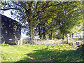
2
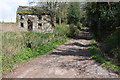
Isolated ruined cottage
By the byway to Wayne Green near Plas Ivor.
Image: © Jonathan Billinger
Taken: 26 Feb 2007
0.07 miles
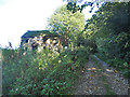
3
Road to Plas Ivor
No through road to Plas Ivor.
Image: © Philip Halling
Taken: 27 Apr 2013
0.09 miles
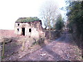
4
Property with potential
A ruinous cottage on a no through road to the south of Cross Ash.
Image: © Philip Halling
Taken: 27 Apr 2013
0.09 miles