IMAGES TAKEN NEAR TO
Cross Ash, ABERGAVENNY, NP7 8PP
Introduction
This page details the photographs taken nearby to NP7 8PP by members of the Geograph project.
The Geograph project started in 2005 with the aim of publishing, organising and preserving representative images for every square kilometre of Great Britain, Ireland and the Isle of Man.

There are currently over 7.5m images from over14,400 individuals and you can help contribute to the project by visiting https://www.geograph.org.uk
Image Map
Images are licensed for reuse under creativecommons.org/licenses/by-sa/2.0
Notes
- Clicking on the map will re-center to the selected point.
- The higher the marker number, the further away the image location is from the centre of the postcode.
Image Listing (34 Images Found)
Images are licensed for reuse under creativecommons.org/licenses/by-sa/2.0
Image
Details
Distance
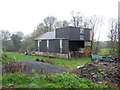
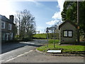
1
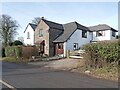
'Peelers' Cottage
Formerly, The Old Police Station!
Image: © Roger Cornfoot
Taken: 5 Feb 2023
0.00 miles
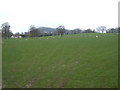
3
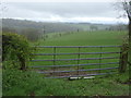
Field and hedgerow near Cross Ash Farm
Off the B4521.
Image: © JThomas
Taken: 4 Apr 2019
0.12 miles
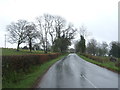
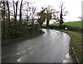
4
Bend in the B4521
Looking north - towards Skenfrith.
Image: © JThomas
Taken: 4 Apr 2019
0.14 miles
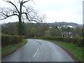
7
Bend in the B4521, Cross Ash, Monmouthshire
This way to Abergavenny, 9 miles (c14.5 km) ahead.
Image: © Jaggery
Taken: 12 Nov 2017
0.16 miles
8
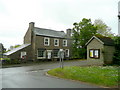
Old Post Office, Cross Ash
Converted to a private house by the B4521.
Image: © Jonathan Billinger
Taken: 18 May 2009
0.18 miles
9
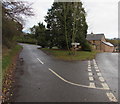
Junction in Cross Ash, Monmouthshire
On the left, the road to Grosmont diverges from the B4521.
Image: © Jaggery
Taken: 12 Nov 2017
0.18 miles
10
The road to Grosmont, near Cross Ash
Image: © Ruth Sharville
Taken: 16 Feb 2014
0.19 miles