IMAGES TAKEN NEAR TO
Llangattock Lingoed, ABERGAVENNY, NP7 8NS
Introduction
This page details the photographs taken nearby to NP7 8NS by members of the Geograph project.
The Geograph project started in 2005 with the aim of publishing, organising and preserving representative images for every square kilometre of Great Britain, Ireland and the Isle of Man.

There are currently over 7.5m images from over14,400 individuals and you can help contribute to the project by visiting https://www.geograph.org.uk
Image Map
Images are licensed for reuse under creativecommons.org/licenses/by-sa/2.0
Notes
- Clicking on the map will re-center to the selected point.
- The higher the marker number, the further away the image location is from the centre of the postcode.
Image Listing (5 Images Found)
Images are licensed for reuse under creativecommons.org/licenses/by-sa/2.0
Image
Details
Distance
1
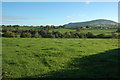
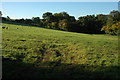
Farmland near Llangattock Lingoed
Farmland to the west of Great House near Llangattock Lingoed, the hill in the background is Graig Syfyrddin.
Image: © Philip Halling
Taken: 16 Oct 2010
0.07 miles
2
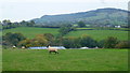
Grazing land west of Great House
Part of Great House farm buildings can be seen in this view north-east towards Edmund's Tump.
Image: © Jonathan Billinger
Taken: 17 Oct 2015
0.10 miles
3
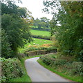
Lane near Great House
Looking east towards the Old Inn.
Image: © Jonathan Billinger
Taken: 17 Oct 2015
0.11 miles
4
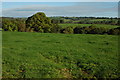
Farmland near Llangattock Lingoed
Farmland to the east of Llangattock Lingoed.
Image: © Philip Halling
Taken: 16 Oct 2010
0.19 miles
5
Field near Bont
Sheep grazing in a field near Bont.
Image: © Philip Halling
Taken: 16 Oct 2010
0.20 miles